You are here: Home > Network List > IU - Global Seismograph Network (GSN - IRIS/USGS) Stations List
> Station PMG Port Moresby, New Guinea > Earthquake Result Viewer
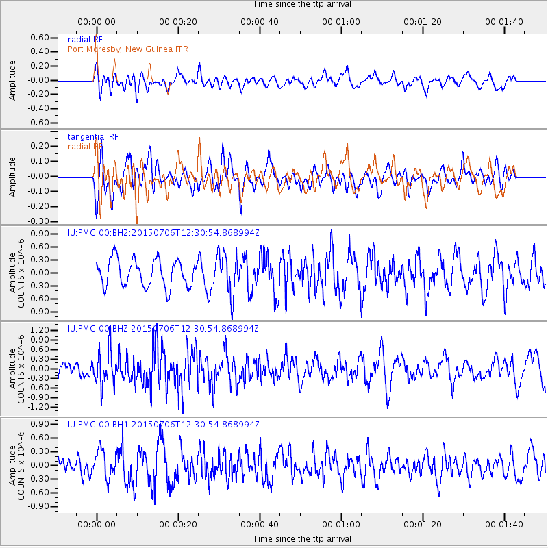
PMG Port Moresby, New Guinea - Earthquake Result Viewer
*The percent match for this event was below the threshold and hence no stack was calculated.
| Earthquake location: |
Tonga Islands |
| Earthquake latitude/longitude: |
-20.8/-174.5 |
| Earthquake time(UTC): |
2015/07/06 (187) 12:24:00 GMT |
| Earthquake Depth: |
1.0 km |
| Earthquake Magnitude: |
6.2 MO |
| Earthquake Catalog/Contributor: |
NEIC PDE/NEIC ALERT |
|
| Network: |
IU Global Seismograph Network (GSN - IRIS/USGS) |
| Station: |
PMG Port Moresby, New Guinea |
| Lat/Lon: |
9.40 S/147.16 E |
| Elevation: |
90 m |
|
| Distance: |
38.6 deg |
| Az: |
281.179 deg |
| Baz: |
111.52 deg |
| Ray Param: |
$rayparam |
*The percent match for this event was below the threshold and hence was not used in the summary stack. |
|
| Radial Match: |
45.232937 % |
| Radial Bump: |
400 |
| Transverse Match: |
51.44274 % |
| Transverse Bump: |
400 |
| SOD ConfigId: |
976571 |
| Insert Time: |
2015-07-20 12:49:29.101 +0000 |
| GWidth: |
2.5 |
| Max Bumps: |
400 |
| Tol: |
0.001 |
|
Signal To Noise
| Channel | StoN | STA | LTA |
| IU:PMG:00:BHZ:20150706T12:30:54.868994Z | 2.9332664 | 5.47271E-7 | 1.8657393E-7 |
| IU:PMG:00:BH1:20150706T12:30:54.868994Z | 1.7506149 | 3.1277585E-7 | 1.7866628E-7 |
| IU:PMG:00:BH2:20150706T12:30:54.868994Z | 1.513816 | 4.6497306E-7 | 3.0715296E-7 |
| Arrivals |
| Ps | |
| PpPs | |
| PsPs/PpSs | |


