You are here: Home > Network List > TA - USArray Transportable Network (new EarthScope stations) Stations List
> Station J25K Salcha River, AK, USA > Earthquake Result Viewer
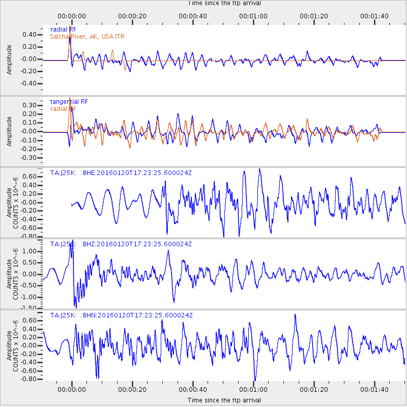
J25K Salcha River, AK, USA - Earthquake Result Viewer
*The percent match for this event was below the threshold and hence no stack was calculated.
| Earthquake location: |
Qinghai, China |
| Earthquake latitude/longitude: |
37.7/101.6 |
| Earthquake time(UTC): |
2016/01/20 (020) 17:13:14 GMT |
| Earthquake Depth: |
10 km |
| Earthquake Magnitude: |
5.9 MWB |
| Earthquake Catalog/Contributor: |
NEIC PDE/NEIC COMCAT |
|
| Network: |
TA USArray Transportable Network (new EarthScope stations) |
| Station: |
J25K Salcha River, AK, USA |
| Lat/Lon: |
64.61 N/145.37 W |
| Elevation: |
949 m |
|
| Distance: |
65.4 deg |
| Az: |
25.861 deg |
| Baz: |
306.641 deg |
| Ray Param: |
$rayparam |
*The percent match for this event was below the threshold and hence was not used in the summary stack. |
|
| Radial Match: |
54.241116 % |
| Radial Bump: |
400 |
| Transverse Match: |
55.064655 % |
| Transverse Bump: |
400 |
| SOD ConfigId: |
7422571 |
| Insert Time: |
2019-04-21 19:02:40.077 +0000 |
| GWidth: |
2.5 |
| Max Bumps: |
400 |
| Tol: |
0.001 |
|
Signal To Noise
| Channel | StoN | STA | LTA |
| TA:J25K: :BHZ:20160120T17:23:25.600024Z | 4.9797134 | 9.095101E-7 | 1.8264305E-7 |
| TA:J25K: :BHN:20160120T17:23:25.600024Z | 1.2664969 | 2.4144845E-7 | 1.9064274E-7 |
| TA:J25K: :BHE:20160120T17:23:25.600024Z | 1.6944456 | 3.4022662E-7 | 2.0078936E-7 |
| Arrivals |
| Ps | |
| PpPs | |
| PsPs/PpSs | |


