You are here: Home > Network List > TA - USArray Transportable Network (new EarthScope stations) Stations List
> Station M27K Edge Creek, AK, USA > Earthquake Result Viewer
M27K Edge Creek, AK, USA - Earthquake Result Viewer
| Earthquake location: |
Qinghai, China |
| Earthquake latitude/longitude: |
37.7/101.6 |
| Earthquake time(UTC): |
2016/01/20 (020) 17:13:14 GMT |
| Earthquake Depth: |
10 km |
| Earthquake Magnitude: |
5.9 MWB |
| Earthquake Catalog/Contributor: |
NEIC PDE/NEIC COMCAT |
|
| Network: |
TA USArray Transportable Network (new EarthScope stations) |
| Station: |
M27K Edge Creek, AK, USA |
| Lat/Lon: |
62.36 N/141.88 W |
| Elevation: |
1536 m |
|
| Distance: |
68.1 deg |
| Az: |
26.733 deg |
| Baz: |
310.106 deg |
| Ray Param: |
0.056552034 |
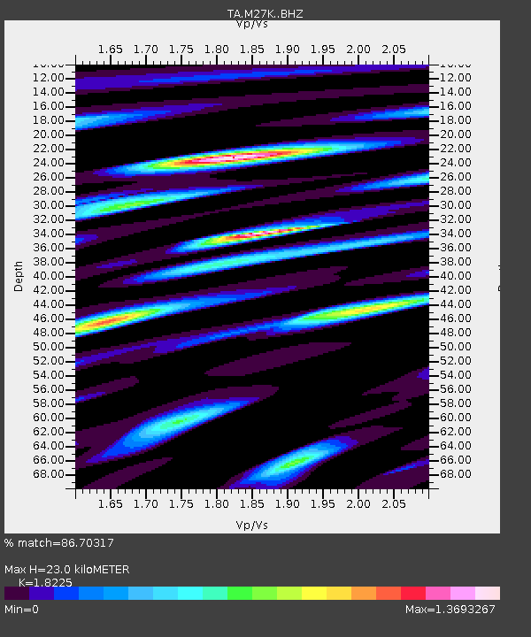
| Estimated Moho Depth: |
23.0 km |
| Estimated Crust Vp/Vs: |
1.82 |
| Assumed Crust Vp: |
6.566 km/s |
| Estimated Crust Vs: |
3.603 km/s |
| Estimated Crust Poisson's Ratio: |
0.28 |
|
| Radial Match: |
86.70317 % |
| Radial Bump: |
400 |
| Transverse Match: |
76.71103 % |
| Transverse Bump: |
400 |
| SOD ConfigId: |
7422571 |
| Insert Time: |
2019-04-21 19:02:51.825 +0000 |
| GWidth: |
2.5 |
| Max Bumps: |
400 |
| Tol: |
0.001 |
|

Signal To Noise
| Channel | StoN | STA | LTA |
| TA:M27K: :BHZ:20160120T17:23:42.350024Z | 12.641568 | 2.72906E-6 | 2.1587988E-7 |
| TA:M27K: :BHN:20160120T17:23:42.350024Z | 4.9917727 | 1.3533462E-6 | 2.7111534E-7 |
| TA:M27K: :BHE:20160120T17:23:42.350024Z | 3.7845845 | 9.1659524E-7 | 2.421918E-7 |
| Arrivals |
| Ps | 3.0 SECOND |
| PpPs | 9.5 SECOND |
| PsPs/PpSs | 12 SECOND |


