You are here: Home > Network List > TA - USArray Transportable Network (new EarthScope stations) Stations List
> Station N25K Chitina, Valdez-Cordova, AK, USA > Earthquake Result Viewer
N25K Chitina, Valdez-Cordova, AK, USA - Earthquake Result Viewer
| Earthquake location: |
Qinghai, China |
| Earthquake latitude/longitude: |
37.7/101.6 |
| Earthquake time(UTC): |
2016/01/20 (020) 17:13:14 GMT |
| Earthquake Depth: |
10 km |
| Earthquake Magnitude: |
5.9 MWB |
| Earthquake Catalog/Contributor: |
NEIC PDE/NEIC COMCAT |
|
| Network: |
TA USArray Transportable Network (new EarthScope stations) |
| Station: |
N25K Chitina, Valdez-Cordova, AK, USA |
| Lat/Lon: |
61.61 N/144.60 W |
| Elevation: |
1087 m |
|
| Distance: |
67.5 deg |
| Az: |
28.242 deg |
| Baz: |
308.278 deg |
| Ray Param: |
0.05689018 |
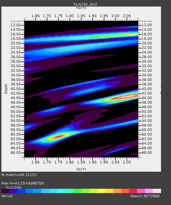
| Estimated Moho Depth: |
43.25 km |
| Estimated Crust Vp/Vs: |
2.05 |
| Assumed Crust Vp: |
6.566 km/s |
| Estimated Crust Vs: |
3.211 km/s |
| Estimated Crust Poisson's Ratio: |
0.34 |
|
| Radial Match: |
84.31153 % |
| Radial Bump: |
400 |
| Transverse Match: |
79.599495 % |
| Transverse Bump: |
400 |
| SOD ConfigId: |
7422571 |
| Insert Time: |
2019-04-21 19:02:56.862 +0000 |
| GWidth: |
2.5 |
| Max Bumps: |
400 |
| Tol: |
0.001 |
|
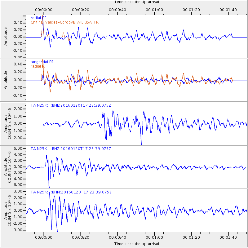
Signal To Noise
| Channel | StoN | STA | LTA |
| TA:N25K: :BHZ:20160120T17:23:39.075Z | 8.147433 | 2.7961048E-6 | 3.4318842E-7 |
| TA:N25K: :BHN:20160120T17:23:39.075Z | 4.474904 | 1.2361179E-6 | 2.7623338E-7 |
| TA:N25K: :BHE:20160120T17:23:39.075Z | 4.186441 | 9.888865E-7 | 2.3621175E-7 |
| Arrivals |
| Ps | 7.1 SECOND |
| PpPs | 19 SECOND |
| PsPs/PpSs | 26 SECOND |


