You are here: Home > Network List > US - United States National Seismic Network Stations List
> Station DGMT Dagmar, Montana, USA > Earthquake Result Viewer
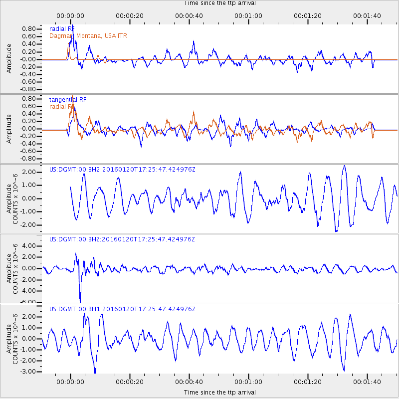
DGMT Dagmar, Montana, USA - Earthquake Result Viewer
*The percent match for this event was below the threshold and hence no stack was calculated.
| Earthquake location: |
Qinghai, China |
| Earthquake latitude/longitude: |
37.7/101.6 |
| Earthquake time(UTC): |
2016/01/20 (020) 17:13:14 GMT |
| Earthquake Depth: |
10 km |
| Earthquake Magnitude: |
5.9 MWB |
| Earthquake Catalog/Contributor: |
NEIC PDE/NEIC COMCAT |
|
| Network: |
US United States National Seismic Network |
| Station: |
DGMT Dagmar, Montana, USA |
| Lat/Lon: |
48.47 N/104.20 W |
| Elevation: |
0.0 m |
|
| Distance: |
91.2 deg |
| Az: |
16.828 deg |
| Baz: |
339.821 deg |
| Ray Param: |
$rayparam |
*The percent match for this event was below the threshold and hence was not used in the summary stack. |
|
| Radial Match: |
62.823162 % |
| Radial Bump: |
400 |
| Transverse Match: |
55.62304 % |
| Transverse Bump: |
369 |
| SOD ConfigId: |
7422571 |
| Insert Time: |
2019-04-21 19:03:08.212 +0000 |
| GWidth: |
2.5 |
| Max Bumps: |
400 |
| Tol: |
0.001 |
|
Signal To Noise
| Channel | StoN | STA | LTA |
| US:DGMT:00:BHZ:20160120T17:25:47.424976Z | 5.011114 | 1.9008834E-6 | 3.7933347E-7 |
| US:DGMT:00:BH1:20160120T17:25:47.424976Z | 1.215458 | 8.8142207E-7 | 7.2517685E-7 |
| US:DGMT:00:BH2:20160120T17:25:47.424976Z | 0.6301253 | 5.447345E-7 | 8.64486E-7 |
| Arrivals |
| Ps | |
| PpPs | |
| PsPs/PpSs | |


