You are here: Home > Network List > UW - Pacific Northwest Regional Seismic Network Stations List
> Station MRBL Marblemount, WA, USA > Earthquake Result Viewer
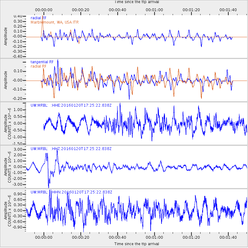
MRBL Marblemount, WA, USA - Earthquake Result Viewer
*The percent match for this event was below the threshold and hence no stack was calculated.
| Earthquake location: |
Qinghai, China |
| Earthquake latitude/longitude: |
37.7/101.6 |
| Earthquake time(UTC): |
2016/01/20 (020) 17:13:14 GMT |
| Earthquake Depth: |
10 km |
| Earthquake Magnitude: |
5.9 MWB |
| Earthquake Catalog/Contributor: |
NEIC PDE/NEIC COMCAT |
|
| Network: |
UW Pacific Northwest Regional Seismic Network |
| Station: |
MRBL Marblemount, WA, USA |
| Lat/Lon: |
48.52 N/121.48 W |
| Elevation: |
75 m |
|
| Distance: |
86.0 deg |
| Az: |
27.074 deg |
| Baz: |
327.122 deg |
| Ray Param: |
$rayparam |
*The percent match for this event was below the threshold and hence was not used in the summary stack. |
|
| Radial Match: |
55.18851 % |
| Radial Bump: |
400 |
| Transverse Match: |
58.321167 % |
| Transverse Bump: |
400 |
| SOD ConfigId: |
7422571 |
| Insert Time: |
2019-04-21 19:03:29.804 +0000 |
| GWidth: |
2.5 |
| Max Bumps: |
400 |
| Tol: |
0.001 |
|
Signal To Noise
| Channel | StoN | STA | LTA |
| UW:MRBL: :HHZ:20160120T17:25:22.838Z | 4.3576903 | 1.5790832E-6 | 3.6236702E-7 |
| UW:MRBL: :HHN:20160120T17:25:22.838Z | 2.0951462 | 4.2491556E-7 | 2.028095E-7 |
| UW:MRBL: :HHE:20160120T17:25:22.838Z | 0.6717387 | 2.461856E-7 | 3.6649013E-7 |
| Arrivals |
| Ps | |
| PpPs | |
| PsPs/PpSs | |


