You are here: Home > Network List > US - United States National Seismic Network Stations List
> Station MSO Missoula, Montana, USA > Earthquake Result Viewer
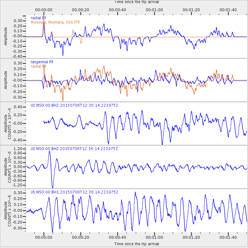
MSO Missoula, Montana, USA - Earthquake Result Viewer
*The percent match for this event was below the threshold and hence no stack was calculated.
| Earthquake location: |
Tonga Islands |
| Earthquake latitude/longitude: |
-20.8/-174.5 |
| Earthquake time(UTC): |
2015/07/06 (187) 12:24:00 GMT |
| Earthquake Depth: |
1.0 km |
| Earthquake Magnitude: |
6.2 MO |
| Earthquake Catalog/Contributor: |
NEIC PDE/NEIC ALERT |
|
| Network: |
US United States National Seismic Network |
| Station: |
MSO Missoula, Montana, USA |
| Lat/Lon: |
46.83 N/113.94 W |
| Elevation: |
1264 m |
|
| Distance: |
86.6 deg |
| Az: |
36.789 deg |
| Baz: |
234.698 deg |
| Ray Param: |
$rayparam |
*The percent match for this event was below the threshold and hence was not used in the summary stack. |
|
| Radial Match: |
85.12615 % |
| Radial Bump: |
400 |
| Transverse Match: |
85.36922 % |
| Transverse Bump: |
400 |
| SOD ConfigId: |
976571 |
| Insert Time: |
2015-07-20 12:52:41.372 +0000 |
| GWidth: |
2.5 |
| Max Bumps: |
400 |
| Tol: |
0.001 |
|
Signal To Noise
| Channel | StoN | STA | LTA |
| US:MSO:00:BHZ:20150706T12:36:14.223975Z | 11.601068 | 5.8588137E-7 | 5.0502365E-8 |
| US:MSO:00:BH1:20150706T12:36:14.223975Z | 2.6429935 | 1.57647E-7 | 5.964714E-8 |
| US:MSO:00:BH2:20150706T12:36:14.223975Z | 2.0796351 | 1.6104606E-7 | 7.743957E-8 |
| Arrivals |
| Ps | |
| PpPs | |
| PsPs/PpSs | |


