You are here: Home > Network List > TA - USArray Transportable Network (new EarthScope stations) Stations List
> Station A04D Lummi Island, WA, USA > Earthquake Result Viewer
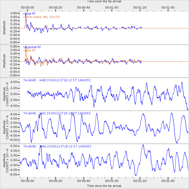
A04D Lummi Island, WA, USA - Earthquake Result Viewer
*The percent match for this event was below the threshold and hence no stack was calculated.
| Earthquake location: |
Off Coast Of Jalisco, Mexico |
| Earthquake latitude/longitude: |
18.8/-107.0 |
| Earthquake time(UTC): |
2016/01/21 (021) 18:06:59 GMT |
| Earthquake Depth: |
10 km |
| Earthquake Magnitude: |
6.6 MWW, 6.9 MI |
| Earthquake Catalog/Contributor: |
NEIC PDE/NEIC COMCAT |
|
| Network: |
TA USArray Transportable Network (new EarthScope stations) |
| Station: |
A04D Lummi Island, WA, USA |
| Lat/Lon: |
48.72 N/122.71 W |
| Elevation: |
13 m |
|
| Distance: |
32.4 deg |
| Az: |
340.405 deg |
| Baz: |
151.339 deg |
| Ray Param: |
$rayparam |
*The percent match for this event was below the threshold and hence was not used in the summary stack. |
|
| Radial Match: |
75.37385 % |
| Radial Bump: |
334 |
| Transverse Match: |
73.199554 % |
| Transverse Bump: |
400 |
| SOD ConfigId: |
7422571 |
| Insert Time: |
2019-04-21 19:16:31.383 +0000 |
| GWidth: |
2.5 |
| Max Bumps: |
400 |
| Tol: |
0.001 |
|
Signal To Noise
| Channel | StoN | STA | LTA |
| TA:A04D: :HHZ:20160121T18:12:57.140005Z | 3.247573 | 3.1346594E-6 | 9.652315E-7 |
| TA:A04D: :HHN:20160121T18:12:57.140005Z | 1.1965708 | 1.2183608E-6 | 1.0182105E-6 |
| TA:A04D: :HHE:20160121T18:12:57.140005Z | 3.2004616 | 1.5915028E-6 | 4.972729E-7 |
| Arrivals |
| Ps | |
| PpPs | |
| PsPs/PpSs | |


