You are here: Home > Network List > TA - USArray Transportable Network (new EarthScope stations) Stations List
> Station E04D Cinebar, WA, USA > Earthquake Result Viewer
E04D Cinebar, WA, USA - Earthquake Result Viewer
| Earthquake location: |
Off Coast Of Jalisco, Mexico |
| Earthquake latitude/longitude: |
18.8/-107.0 |
| Earthquake time(UTC): |
2016/01/21 (021) 18:06:59 GMT |
| Earthquake Depth: |
10 km |
| Earthquake Magnitude: |
6.6 MWW, 6.9 MI |
| Earthquake Catalog/Contributor: |
NEIC PDE/NEIC COMCAT |
|
| Network: |
TA USArray Transportable Network (new EarthScope stations) |
| Station: |
E04D Cinebar, WA, USA |
| Lat/Lon: |
46.56 N/122.57 W |
| Elevation: |
204 m |
|
| Distance: |
30.5 deg |
| Az: |
338.524 deg |
| Baz: |
149.837 deg |
| Ray Param: |
0.07931966 |
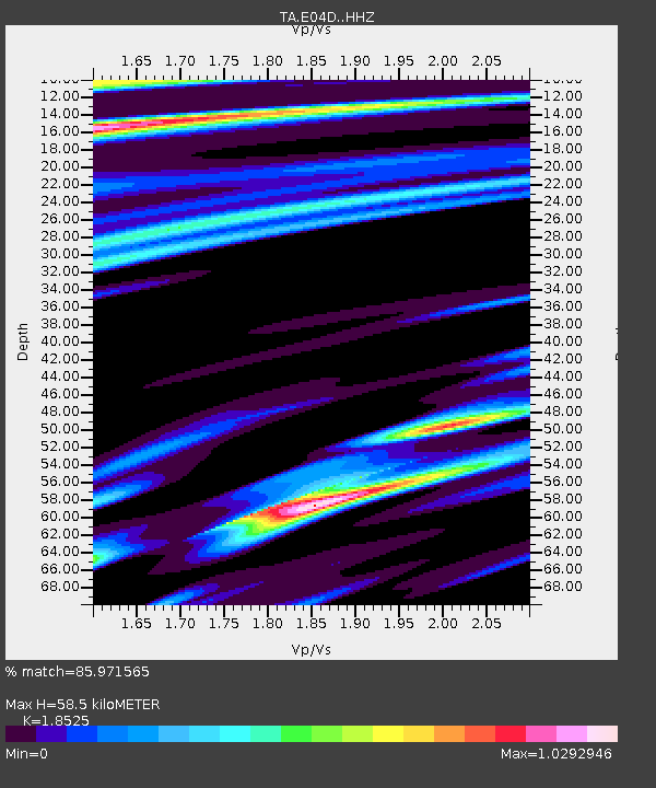
| Estimated Moho Depth: |
58.5 km |
| Estimated Crust Vp/Vs: |
1.85 |
| Assumed Crust Vp: |
6.566 km/s |
| Estimated Crust Vs: |
3.544 km/s |
| Estimated Crust Poisson's Ratio: |
0.29 |
|
| Radial Match: |
85.971565 % |
| Radial Bump: |
400 |
| Transverse Match: |
66.81489 % |
| Transverse Bump: |
400 |
| SOD ConfigId: |
7422571 |
| Insert Time: |
2019-04-21 19:16:35.369 +0000 |
| GWidth: |
2.5 |
| Max Bumps: |
400 |
| Tol: |
0.001 |
|

Signal To Noise
| Channel | StoN | STA | LTA |
| TA:E04D: :HHZ:20160121T18:12:40.180013Z | 3.6986442 | 2.273107E-6 | 6.145784E-7 |
| TA:E04D: :HHN:20160121T18:12:40.180013Z | 1.8386492 | 1.4907497E-6 | 8.107853E-7 |
| TA:E04D: :HHE:20160121T18:12:40.180013Z | 0.74729687 | 1.151112E-6 | 1.5403676E-6 |
| Arrivals |
| Ps | 8.2 SECOND |
| PpPs | 23 SECOND |
| PsPs/PpSs | 32 SECOND |


