You are here: Home > Network List > IC - New China Digital Seismograph Network Stations List
> Station QIZ Qiongzhong, Guangduong Province, China > Earthquake Result Viewer
QIZ Qiongzhong, Guangduong Province, China - Earthquake Result Viewer
| Earthquake location: |
Kuril Islands |
| Earthquake latitude/longitude: |
44.3/150.0 |
| Earthquake time(UTC): |
2002/10/19 (292) 12:09:05 GMT |
| Earthquake Depth: |
33 km |
| Earthquake Magnitude: |
5.4 MB, 6.2 MS, 6.4 MW, 6.1 MW |
| Earthquake Catalog/Contributor: |
WHDF/NEIC |
|
| Network: |
IC New China Digital Seismograph Network |
| Station: |
QIZ Qiongzhong, Guangduong Province, China |
| Lat/Lon: |
19.03 N/109.84 E |
| Elevation: |
230 m |
|
| Distance: |
41.8 deg |
| Az: |
246.049 deg |
| Baz: |
43.922 deg |
| Ray Param: |
0.07347101 |
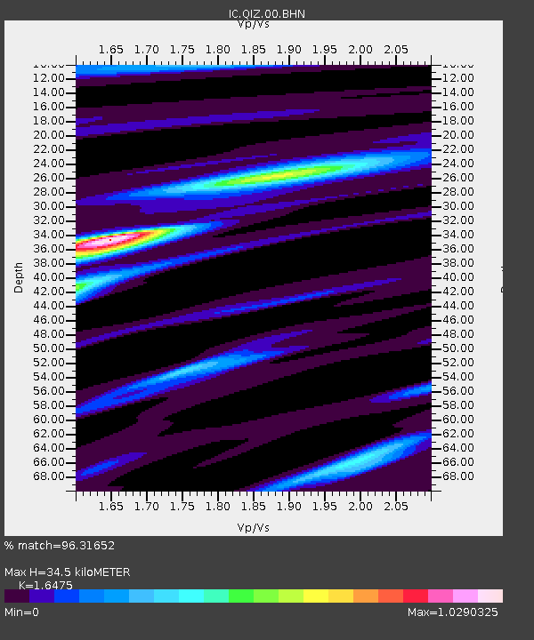
| Estimated Moho Depth: |
34.5 km |
| Estimated Crust Vp/Vs: |
1.65 |
| Assumed Crust Vp: |
6.182 km/s |
| Estimated Crust Vs: |
3.753 km/s |
| Estimated Crust Poisson's Ratio: |
0.21 |
|
| Radial Match: |
96.31652 % |
| Radial Bump: |
392 |
| Transverse Match: |
74.783005 % |
| Transverse Bump: |
400 |
| SOD ConfigId: |
4714 |
| Insert Time: |
2010-03-04 23:27:46.303 +0000 |
| GWidth: |
2.5 |
| Max Bumps: |
400 |
| Tol: |
0.001 |
|
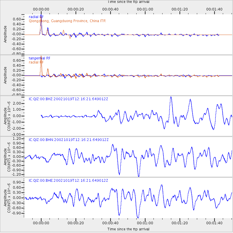
Signal To Noise
| Channel | StoN | STA | LTA |
| IC:QIZ:00:BHN:20021019T12:16:21.649012Z | 3.8062816 | 1.8697612E-7 | 4.912304E-8 |
| IC:QIZ:00:BHE:20021019T12:16:21.649012Z | 3.0489879 | 1.477927E-7 | 4.8472707E-8 |
| IC:QIZ:00:BHZ:20021019T12:16:21.649012Z | 5.262397 | 4.301073E-7 | 8.17322E-8 |
| Arrivals |
| Ps | 3.9 SECOND |
| PpPs | 14 SECOND |
| PsPs/PpSs | 18 SECOND |


