You are here: Home > Network List > TA - USArray Transportable Network (new EarthScope stations) Stations List
> Station H21K Melozitna River, AK, USA > Earthquake Result Viewer
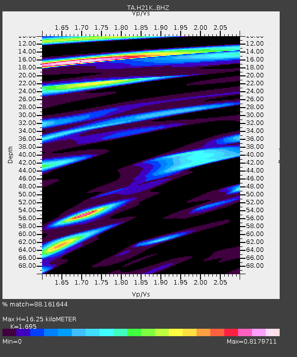
H21K Melozitna River, AK, USA - Earthquake Result Viewer
| Earthquake location: |
Off Coast Of Jalisco, Mexico |
| Earthquake latitude/longitude: |
18.8/-107.0 |
| Earthquake time(UTC): |
2016/01/21 (021) 18:06:59 GMT |
| Earthquake Depth: |
10 km |
| Earthquake Magnitude: |
6.6 MWW, 6.9 MI |
| Earthquake Catalog/Contributor: |
NEIC PDE/NEIC COMCAT |
|
| Network: |
TA USArray Transportable Network (new EarthScope stations) |
| Station: |
H21K Melozitna River, AK, USA |
| Lat/Lon: |
65.66 N/152.80 W |
| Elevation: |
520 m |
|
| Distance: |
55.6 deg |
| Az: |
338.861 deg |
| Baz: |
124.512 deg |
| Ray Param: |
0.06471471 |
| Estimated Moho Depth: |
16.25 km |
| Estimated Crust Vp/Vs: |
1.70 |
| Assumed Crust Vp: |
6.566 km/s |
| Estimated Crust Vs: |
3.874 km/s |
| Estimated Crust Poisson's Ratio: |
0.23 |
|
| Radial Match: |
88.161644 % |
| Radial Bump: |
400 |
| Transverse Match: |
77.57634 % |
| Transverse Bump: |
400 |
| SOD ConfigId: |
7422571 |
| Insert Time: |
2019-04-21 19:16:35.979 +0000 |
| GWidth: |
2.5 |
| Max Bumps: |
400 |
| Tol: |
0.001 |
|

Signal To Noise
| Channel | StoN | STA | LTA |
| TA:H21K: :BHZ:20160121T18:16:02.225027Z | 13.744033 | 1.3275893E-6 | 9.6593865E-8 |
| TA:H21K: :BHN:20160121T18:16:02.225027Z | 2.2313414 | 4.2231923E-7 | 1.8926697E-7 |
| TA:H21K: :BHE:20160121T18:16:02.225027Z | 3.920544 | 6.5337224E-7 | 1.6665346E-7 |
| Arrivals |
| Ps | 1.8 SECOND |
| PpPs | 6.3 SECOND |
| PsPs/PpSs | 8.1 SECOND |


