You are here: Home > Network List > TA - USArray Transportable Network (new EarthScope stations) Stations List
> Station O56A Blue Knob State Park, Imler, PA, USA > Earthquake Result Viewer
O56A Blue Knob State Park, Imler, PA, USA - Earthquake Result Viewer
| Earthquake location: |
Off Coast Of Jalisco, Mexico |
| Earthquake latitude/longitude: |
18.8/-107.0 |
| Earthquake time(UTC): |
2016/01/21 (021) 18:06:59 GMT |
| Earthquake Depth: |
10 km |
| Earthquake Magnitude: |
6.6 MWW, 6.9 MI |
| Earthquake Catalog/Contributor: |
NEIC PDE/NEIC COMCAT |
|
| Network: |
TA USArray Transportable Network (new EarthScope stations) |
| Station: |
O56A Blue Knob State Park, Imler, PA, USA |
| Lat/Lon: |
40.27 N/78.57 W |
| Elevation: |
684 m |
|
| Distance: |
32.4 deg |
| Az: |
42.74 deg |
| Baz: |
237.143 deg |
| Ray Param: |
0.078662395 |
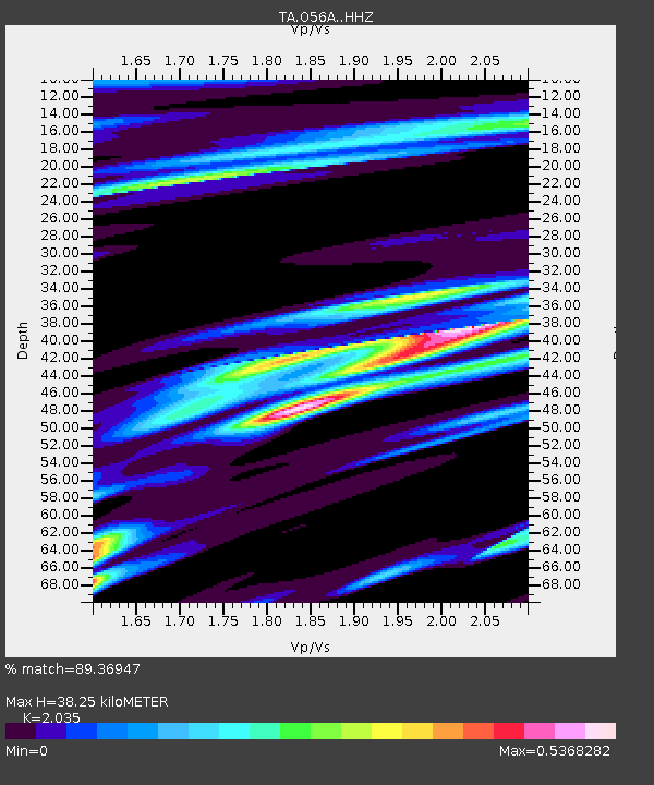
| Estimated Moho Depth: |
38.25 km |
| Estimated Crust Vp/Vs: |
2.04 |
| Assumed Crust Vp: |
6.121 km/s |
| Estimated Crust Vs: |
3.008 km/s |
| Estimated Crust Poisson's Ratio: |
0.34 |
|
| Radial Match: |
89.36947 % |
| Radial Bump: |
305 |
| Transverse Match: |
74.21032 % |
| Transverse Bump: |
345 |
| SOD ConfigId: |
7422571 |
| Insert Time: |
2019-04-21 19:16:57.376 +0000 |
| GWidth: |
2.5 |
| Max Bumps: |
400 |
| Tol: |
0.001 |
|

Signal To Noise
| Channel | StoN | STA | LTA |
| TA:O56A: :HHZ:20160121T18:12:56.909994Z | 2.5379767 | 1.0333788E-6 | 4.0716634E-7 |
| TA:O56A: :HHN:20160121T18:12:56.909994Z | 1.251854 | 4.4788297E-7 | 3.5777575E-7 |
| TA:O56A: :HHE:20160121T18:12:56.909994Z | 1.8018953 | 6.286528E-7 | 3.4888419E-7 |
| Arrivals |
| Ps | 6.9 SECOND |
| PpPs | 18 SECOND |
| PsPs/PpSs | 25 SECOND |


