You are here: Home > Network List > XD14 - Illuminating the architecture of the greater Mount St. Helens magmatic systems f Stations List
> Station MA05 "Mount St Helens, WA" > Earthquake Result Viewer
MA05 "Mount St Helens, WA" - Earthquake Result Viewer
| Earthquake location: |
Off Coast Of Jalisco, Mexico |
| Earthquake latitude/longitude: |
18.8/-107.0 |
| Earthquake time(UTC): |
2016/01/21 (021) 18:06:59 GMT |
| Earthquake Depth: |
10 km |
| Earthquake Magnitude: |
6.6 MWW, 6.9 MI |
| Earthquake Catalog/Contributor: |
NEIC PDE/NEIC COMCAT |
|
| Network: |
XD Illuminating the architecture of the greater Mount St. Helens magmatic systems f |
| Station: |
MA05 "Mount St Helens, WA" |
| Lat/Lon: |
46.75 N/122.23 W |
| Elevation: |
488 m |
|
| Distance: |
30.5 deg |
| Az: |
339.12 deg |
| Baz: |
150.597 deg |
| Ray Param: |
0.07930515 |
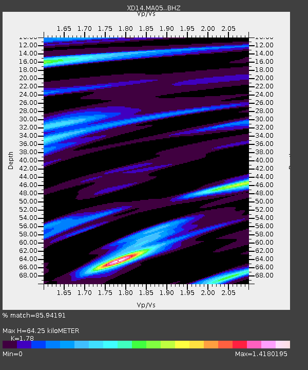
| Estimated Moho Depth: |
64.25 km |
| Estimated Crust Vp/Vs: |
1.78 |
| Assumed Crust Vp: |
6.566 km/s |
| Estimated Crust Vs: |
3.689 km/s |
| Estimated Crust Poisson's Ratio: |
0.27 |
|
| Radial Match: |
85.94191 % |
| Radial Bump: |
400 |
| Transverse Match: |
50.027782 % |
| Transverse Bump: |
400 |
| SOD ConfigId: |
7422571 |
| Insert Time: |
2019-04-21 19:17:38.201 +0000 |
| GWidth: |
2.5 |
| Max Bumps: |
400 |
| Tol: |
0.001 |
|

Signal To Noise
| Channel | StoN | STA | LTA |
| XD:MA05: :BHZ:20160121T18:12:40.675009Z | 2.7333477 | 1.9639936E-6 | 7.1853043E-7 |
| XD:MA05: :BHN:20160121T18:12:40.675009Z | 2.0540004 | 1.1747617E-6 | 5.719384E-7 |
| XD:MA05: :BHE:20160121T18:12:40.675009Z | 0.74985147 | 3.8032096E-7 | 5.0719507E-7 |
| Arrivals |
| Ps | 8.3 SECOND |
| PpPs | 25 SECOND |
| PsPs/PpSs | 33 SECOND |


