You are here: Home > Network List > XD14 - Illuminating the architecture of the greater Mount St. Helens magmatic systems f Stations List
> Station MB07 "Mount St Helens, WA" > Earthquake Result Viewer
MB07 "Mount St Helens, WA" - Earthquake Result Viewer
| Earthquake location: |
Off Coast Of Jalisco, Mexico |
| Earthquake latitude/longitude: |
18.8/-107.0 |
| Earthquake time(UTC): |
2016/01/21 (021) 18:06:59 GMT |
| Earthquake Depth: |
10 km |
| Earthquake Magnitude: |
6.6 MWW, 6.9 MI |
| Earthquake Catalog/Contributor: |
NEIC PDE/NEIC COMCAT |
|
| Network: |
XD Illuminating the architecture of the greater Mount St. Helens magmatic systems f |
| Station: |
MB07 "Mount St Helens, WA" |
| Lat/Lon: |
46.62 N/122.04 W |
| Elevation: |
878 m |
|
| Distance: |
30.4 deg |
| Az: |
339.211 deg |
| Baz: |
150.81 deg |
| Ray Param: |
0.07935141 |
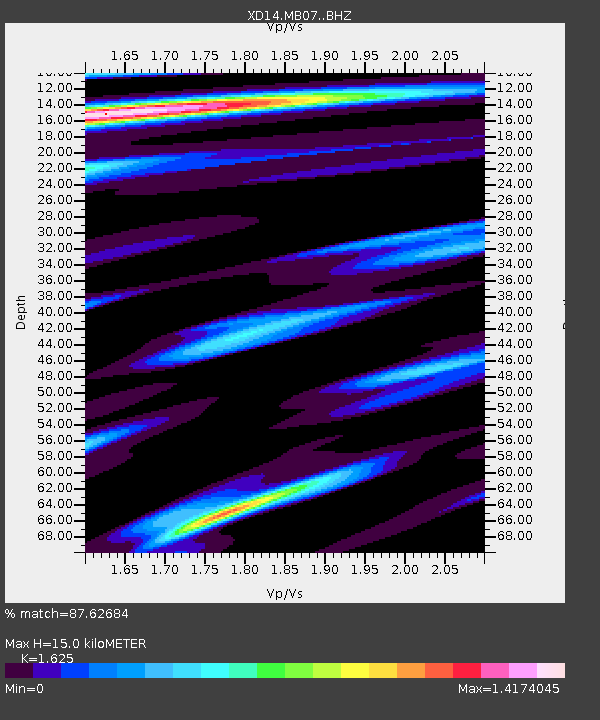
| Estimated Moho Depth: |
15.0 km |
| Estimated Crust Vp/Vs: |
1.62 |
| Assumed Crust Vp: |
6.566 km/s |
| Estimated Crust Vs: |
4.041 km/s |
| Estimated Crust Poisson's Ratio: |
0.20 |
|
| Radial Match: |
87.62684 % |
| Radial Bump: |
330 |
| Transverse Match: |
50.019035 % |
| Transverse Bump: |
400 |
| SOD ConfigId: |
7422571 |
| Insert Time: |
2019-04-21 19:17:39.102 +0000 |
| GWidth: |
2.5 |
| Max Bumps: |
400 |
| Tol: |
0.001 |
|

Signal To Noise
| Channel | StoN | STA | LTA |
| XD:MB07: :BHZ:20160121T18:12:39.12499Z | 5.586406 | 1.9113409E-6 | 3.421414E-7 |
| XD:MB07: :BHN:20160121T18:12:39.12499Z | 3.0723681 | 1.6038407E-6 | 5.22021E-7 |
| XD:MB07: :BHE:20160121T18:12:39.12499Z | 2.588518 | 8.4358004E-7 | 3.2589307E-7 |
| Arrivals |
| Ps | 1.6 SECOND |
| PpPs | 5.5 SECOND |
| PsPs/PpSs | 7.0 SECOND |


