You are here: Home > Network List > XD14 - Illuminating the architecture of the greater Mount St. Helens magmatic systems f Stations List
> Station MK04 "Mount St Helens, WA" > Earthquake Result Viewer
MK04 "Mount St Helens, WA" - Earthquake Result Viewer
| Earthquake location: |
Off Coast Of Jalisco, Mexico |
| Earthquake latitude/longitude: |
18.8/-107.0 |
| Earthquake time(UTC): |
2016/01/21 (021) 18:06:59 GMT |
| Earthquake Depth: |
10 km |
| Earthquake Magnitude: |
6.6 MWW, 6.9 MI |
| Earthquake Catalog/Contributor: |
NEIC PDE/NEIC COMCAT |
|
| Network: |
XD Illuminating the architecture of the greater Mount St. Helens magmatic systems f |
| Station: |
MK04 "Mount St Helens, WA" |
| Lat/Lon: |
46.11 N/122.39 W |
| Elevation: |
482 m |
|
| Distance: |
30.0 deg |
| Az: |
338.291 deg |
| Baz: |
149.763 deg |
| Ray Param: |
0.07943664 |
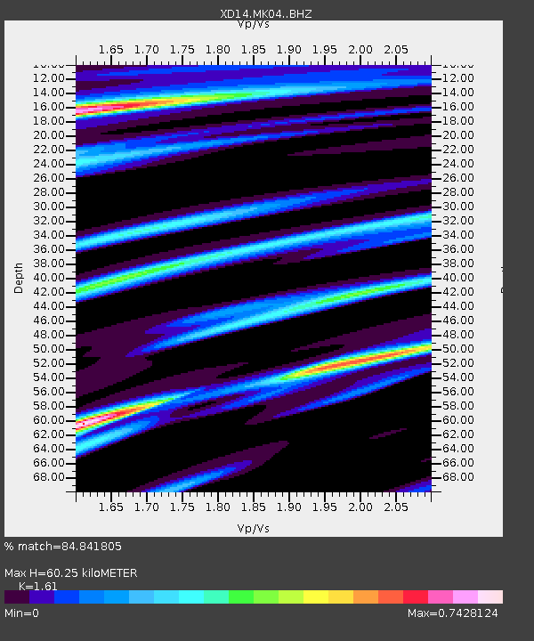
| Estimated Moho Depth: |
60.25 km |
| Estimated Crust Vp/Vs: |
1.61 |
| Assumed Crust Vp: |
6.566 km/s |
| Estimated Crust Vs: |
4.078 km/s |
| Estimated Crust Poisson's Ratio: |
0.19 |
|
| Radial Match: |
84.841805 % |
| Radial Bump: |
298 |
| Transverse Match: |
80.10708 % |
| Transverse Bump: |
400 |
| SOD ConfigId: |
7422571 |
| Insert Time: |
2019-04-21 19:18:02.523 +0000 |
| GWidth: |
2.5 |
| Max Bumps: |
400 |
| Tol: |
0.001 |
|

Signal To Noise
| Channel | StoN | STA | LTA |
| XD:MK04: :BHZ:20160121T18:12:36.254995Z | 3.3668792 | 2.0025884E-6 | 5.9479066E-7 |
| XD:MK04: :BHN:20160121T18:12:36.254995Z | 1.4345148 | 1.1543062E-6 | 8.046667E-7 |
| XD:MK04: :BHE:20160121T18:12:36.254995Z | 1.1474857 | 7.8503643E-7 | 6.8413607E-7 |
| Arrivals |
| Ps | 6.1 SECOND |
| PpPs | 22 SECOND |
| PsPs/PpSs | 28 SECOND |


