You are here: Home > Network List > IC - New China Digital Seismograph Network Stations List
> Station QIZ Qiongzhong, Guangduong Province, China > Earthquake Result Viewer
QIZ Qiongzhong, Guangduong Province, China - Earthquake Result Viewer
| Earthquake location: |
Hokkaido, Japan Region |
| Earthquake latitude/longitude: |
42.1/144.3 |
| Earthquake time(UTC): |
2004/11/11 (316) 10:02:47 GMT |
| Earthquake Depth: |
33 km |
| Earthquake Magnitude: |
5.9 MB, 6.0 MS, 6.1 MW, 6.1 MW |
| Earthquake Catalog/Contributor: |
WHDF/NEIC |
|
| Network: |
IC New China Digital Seismograph Network |
| Station: |
QIZ Qiongzhong, Guangduong Province, China |
| Lat/Lon: |
19.03 N/109.84 E |
| Elevation: |
230 m |
|
| Distance: |
37.2 deg |
| Az: |
242.403 deg |
| Baz: |
44.167 deg |
| Ray Param: |
0.07620384 |
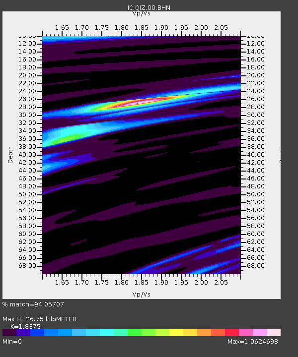
| Estimated Moho Depth: |
26.75 km |
| Estimated Crust Vp/Vs: |
1.84 |
| Assumed Crust Vp: |
6.182 km/s |
| Estimated Crust Vs: |
3.364 km/s |
| Estimated Crust Poisson's Ratio: |
0.29 |
|
| Radial Match: |
94.05707 % |
| Radial Bump: |
254 |
| Transverse Match: |
76.101585 % |
| Transverse Bump: |
400 |
| SOD ConfigId: |
2459 |
| Insert Time: |
2010-03-04 23:28:20.960 +0000 |
| GWidth: |
2.5 |
| Max Bumps: |
400 |
| Tol: |
0.001 |
|
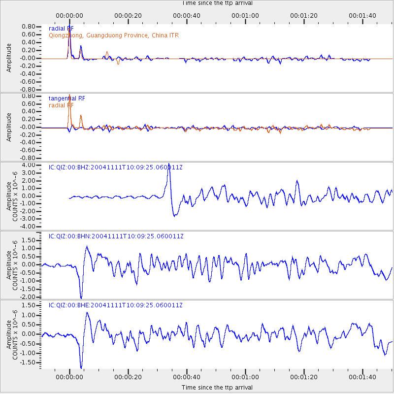
Signal To Noise
| Channel | StoN | STA | LTA |
| IC:QIZ:00:BHN:20041111T10:09:25.060011Z | 16.411371 | 7.988545E-7 | 4.867689E-8 |
| IC:QIZ:00:BHE:20041111T10:09:25.060011Z | 11.228642 | 6.778956E-7 | 6.0372E-8 |
| IC:QIZ:00:BHZ:20041111T10:09:25.060011Z | 18.362719 | 1.6824031E-6 | 9.1620585E-8 |
| Arrivals |
| Ps | 3.9 SECOND |
| PpPs | 12 SECOND |
| PsPs/PpSs | 15 SECOND |


