You are here: Home > Network List > TA - USArray Transportable Network (new EarthScope stations) Stations List
> Station H24K Noodor Dome, AK, USA > Earthquake Result Viewer
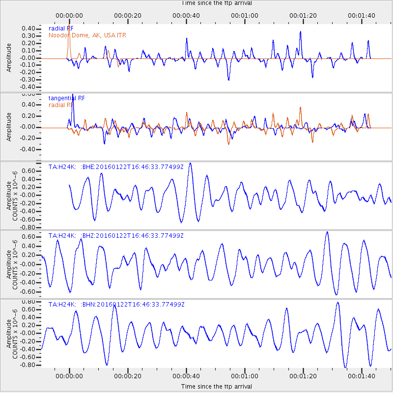
H24K Noodor Dome, AK, USA - Earthquake Result Viewer
*The percent match for this event was below the threshold and hence no stack was calculated.
| Earthquake location: |
Vanuatu Islands Region |
| Earthquake latitude/longitude: |
-13.7/172.1 |
| Earthquake time(UTC): |
2016/01/22 (022) 16:34:35 GMT |
| Earthquake Depth: |
44 km |
| Earthquake Magnitude: |
5.6 MWW, 5.5 MWC |
| Earthquake Catalog/Contributor: |
NEIC PDE/NEIC COMCAT |
|
| Network: |
TA USArray Transportable Network (new EarthScope stations) |
| Station: |
H24K Noodor Dome, AK, USA |
| Lat/Lon: |
65.84 N/147.88 W |
| Elevation: |
814 m |
|
| Distance: |
84.8 deg |
| Az: |
15.429 deg |
| Baz: |
218.911 deg |
| Ray Param: |
$rayparam |
*The percent match for this event was below the threshold and hence was not used in the summary stack. |
|
| Radial Match: |
44.72293 % |
| Radial Bump: |
400 |
| Transverse Match: |
58.659946 % |
| Transverse Bump: |
345 |
| SOD ConfigId: |
7422571 |
| Insert Time: |
2019-04-21 19:22:33.053 +0000 |
| GWidth: |
2.5 |
| Max Bumps: |
400 |
| Tol: |
0.001 |
|
Signal To Noise
| Channel | StoN | STA | LTA |
| TA:H24K: :BHZ:20160122T16:46:33.77499Z | 1.7776057 | 4.3105356E-7 | 2.424911E-7 |
| TA:H24K: :BHN:20160122T16:46:33.77499Z | 1.4724293 | 3.2912342E-7 | 2.235241E-7 |
| TA:H24K: :BHE:20160122T16:46:33.77499Z | 1.0010904 | 2.66804E-7 | 2.6651338E-7 |
| Arrivals |
| Ps | |
| PpPs | |
| PsPs/PpSs | |


