You are here: Home > Network List > CI - Caltech Regional Seismic Network Stations List
> Station BAR Barrett, Tecate, CA, USA > Earthquake Result Viewer
BAR Barrett, Tecate, CA, USA - Earthquake Result Viewer
| Earthquake location: |
Near East Coast Of Kamchatka |
| Earthquake latitude/longitude: |
51.1/157.5 |
| Earthquake time(UTC): |
2006/08/24 (236) 21:50:36 GMT |
| Earthquake Depth: |
43 km |
| Earthquake Magnitude: |
5.9 MB, 6.2 MS, 6.5 MW, 6.5 MW |
| Earthquake Catalog/Contributor: |
WHDF/NEIC |
|
| Network: |
CI Caltech Regional Seismic Network |
| Station: |
BAR Barrett, Tecate, CA, USA |
| Lat/Lon: |
32.68 N/116.67 W |
| Elevation: |
521 m |
|
| Distance: |
62.9 deg |
| Az: |
70.941 deg |
| Baz: |
315.095 deg |
| Ray Param: |
0.059869234 |
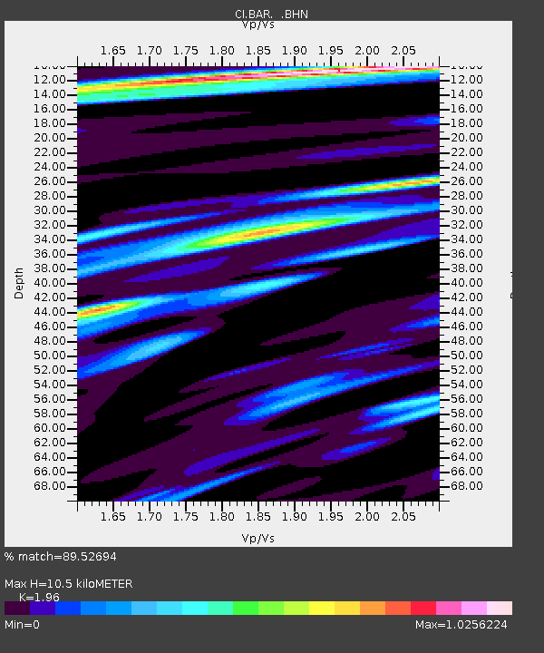
| Estimated Moho Depth: |
10.5 km |
| Estimated Crust Vp/Vs: |
1.96 |
| Assumed Crust Vp: |
6.264 km/s |
| Estimated Crust Vs: |
3.196 km/s |
| Estimated Crust Poisson's Ratio: |
0.32 |
|
| Radial Match: |
89.52694 % |
| Radial Bump: |
400 |
| Transverse Match: |
73.80172 % |
| Transverse Bump: |
400 |
| SOD ConfigId: |
2665 |
| Insert Time: |
2010-02-26 00:05:16.365 +0000 |
| GWidth: |
2.5 |
| Max Bumps: |
400 |
| Tol: |
0.001 |
|
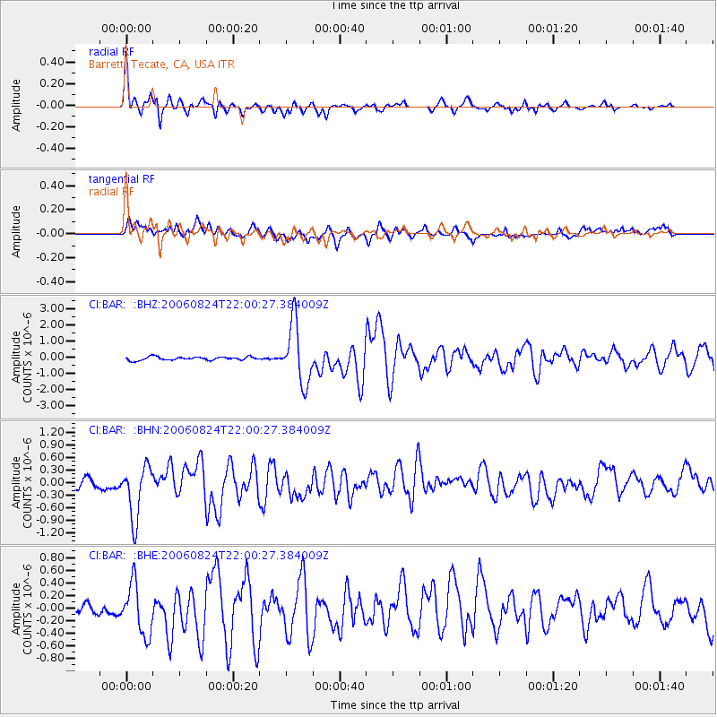
Signal To Noise
| Channel | StoN | STA | LTA |
| CI:BAR: :BHN:20060824T22:00:27.384009Z | 4.80635 | 6.655744E-7 | 1.3847813E-7 |
| CI:BAR: :BHE:20060824T22:00:27.384009Z | 2.6645403 | 4.3728218E-7 | 1.6411168E-7 |
| CI:BAR: :BHZ:20060824T22:00:27.384009Z | 18.347794 | 1.8803058E-6 | 1.02481295E-7 |
| Arrivals |
| Ps | 1.7 SECOND |
| PpPs | 4.8 SECOND |
| PsPs/PpSs | 6.4 SECOND |


