You are here: Home > Network List > IC - New China Digital Seismograph Network Stations List
> Station QIZ Qiongzhong, Guangduong Province, China > Earthquake Result Viewer
QIZ Qiongzhong, Guangduong Province, China - Earthquake Result Viewer
| Earthquake location: |
Kuril Islands |
| Earthquake latitude/longitude: |
46.0/151.4 |
| Earthquake time(UTC): |
2009/04/18 (108) 19:17:58 GMT |
| Earthquake Depth: |
35 km |
| Earthquake Magnitude: |
6.3 MB, 6.3 MS, 6.6 MW, 6.4 MW |
| Earthquake Catalog/Contributor: |
WHDF/NEIC |
|
| Network: |
IC New China Digital Seismograph Network |
| Station: |
QIZ Qiongzhong, Guangduong Province, China |
| Lat/Lon: |
19.03 N/109.84 E |
| Elevation: |
230 m |
|
| Distance: |
43.5 deg |
| Az: |
245.842 deg |
| Baz: |
42.232 deg |
| Ray Param: |
0.072448514 |
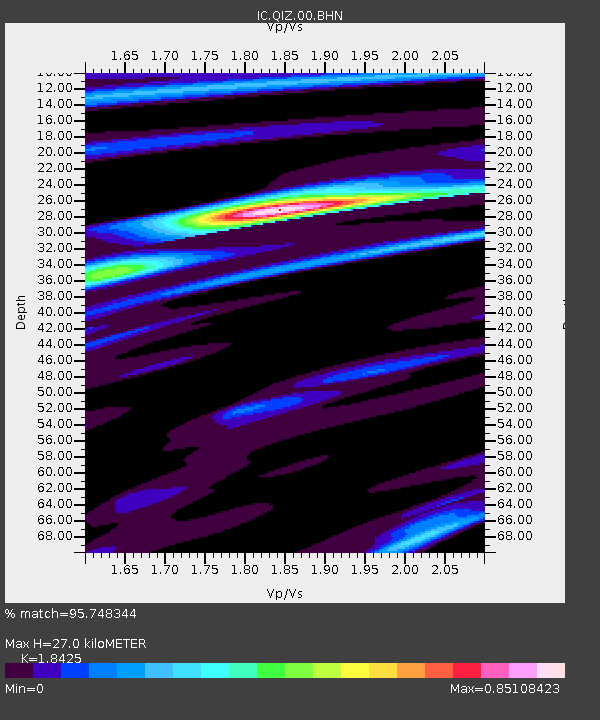
| Estimated Moho Depth: |
27.0 km |
| Estimated Crust Vp/Vs: |
1.84 |
| Assumed Crust Vp: |
6.182 km/s |
| Estimated Crust Vs: |
3.355 km/s |
| Estimated Crust Poisson's Ratio: |
0.29 |
|
| Radial Match: |
95.748344 % |
| Radial Bump: |
275 |
| Transverse Match: |
88.69697 % |
| Transverse Bump: |
400 |
| SOD ConfigId: |
2760 |
| Insert Time: |
2010-03-04 23:29:30.095 +0000 |
| GWidth: |
2.5 |
| Max Bumps: |
400 |
| Tol: |
0.001 |
|
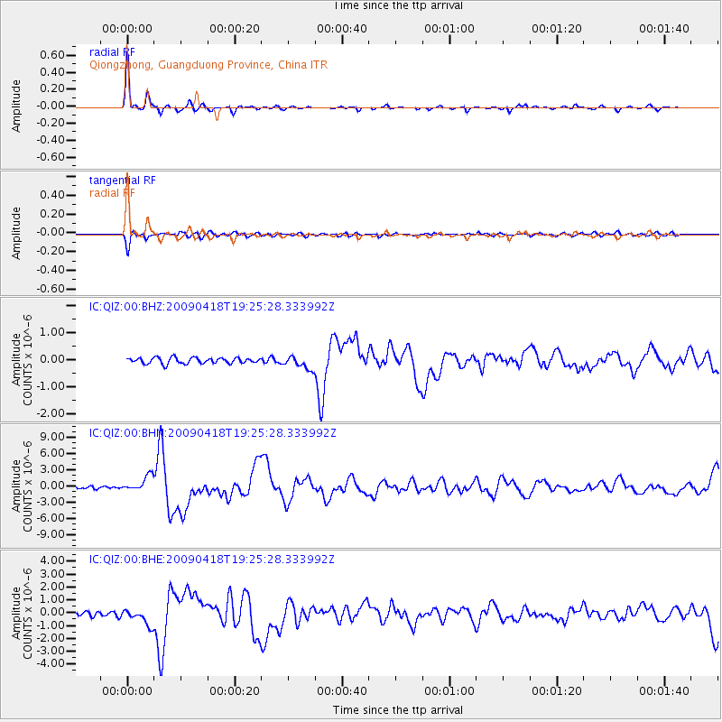
Signal To Noise
| Channel | StoN | STA | LTA |
| IC:QIZ:00:BHN:20090418T19:25:28.333992Z | 4.865746 | 1.4511156E-6 | 2.9823087E-7 |
| IC:QIZ:00:BHE:20090418T19:25:28.333992Z | 4.1624646 | 6.1931183E-7 | 1.4878488E-7 |
| IC:QIZ:00:BHZ:20090418T19:25:28.333992Z | 2.225002 | 2.3875134E-7 | 1.07303876E-7 |
| Arrivals |
| Ps | 3.9 SECOND |
| PpPs | 12 SECOND |
| PsPs/PpSs | 16 SECOND |


