You are here: Home > Network List > CI - Caltech Regional Seismic Network Stations List
> Station MPM Manuel Prospect Mine, California, USA > Earthquake Result Viewer
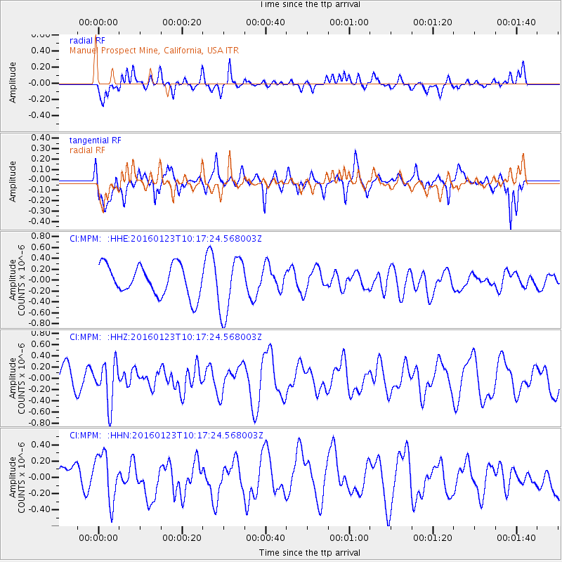
MPM Manuel Prospect Mine, California, USA - Earthquake Result Viewer
*The percent match for this event was below the threshold and hence no stack was calculated.
| Earthquake location: |
Easter Island Region |
| Earthquake latitude/longitude: |
-22.4/-114.0 |
| Earthquake time(UTC): |
2016/01/23 (023) 10:08:01 GMT |
| Earthquake Depth: |
10 km |
| Earthquake Magnitude: |
5.5 MB |
| Earthquake Catalog/Contributor: |
NEIC PDE/NEIC COMCAT |
|
| Network: |
CI Caltech Regional Seismic Network |
| Station: |
MPM Manuel Prospect Mine, California, USA |
| Lat/Lon: |
36.06 N/117.49 W |
| Elevation: |
185 m |
|
| Distance: |
58.2 deg |
| Az: |
356.643 deg |
| Baz: |
176.165 deg |
| Ray Param: |
$rayparam |
*The percent match for this event was below the threshold and hence was not used in the summary stack. |
|
| Radial Match: |
60.530807 % |
| Radial Bump: |
400 |
| Transverse Match: |
60.840496 % |
| Transverse Bump: |
400 |
| SOD ConfigId: |
7422571 |
| Insert Time: |
2019-04-21 19:31:10.793 +0000 |
| GWidth: |
2.5 |
| Max Bumps: |
400 |
| Tol: |
0.001 |
|
Signal To Noise
| Channel | StoN | STA | LTA |
| CI:MPM: :HHZ:20160123T10:17:24.568003Z | 1.5201153 | 3.7199007E-7 | 2.4471174E-7 |
| CI:MPM: :HHN:20160123T10:17:24.568003Z | 1.872384 | 3.0677708E-7 | 1.6384305E-7 |
| CI:MPM: :HHE:20160123T10:17:24.568003Z | 1.732409 | 4.756779E-7 | 2.7457597E-7 |
| Arrivals |
| Ps | |
| PpPs | |
| PsPs/PpSs | |


