You are here: Home > Network List > IC - New China Digital Seismograph Network Stations List
> Station QIZ Qiongzhong, Guangduong Province, China > Earthquake Result Viewer
QIZ Qiongzhong, Guangduong Province, China - Earthquake Result Viewer
| Earthquake location: |
East Of Kuril Islands |
| Earthquake latitude/longitude: |
46.8/154.1 |
| Earthquake time(UTC): |
2005/10/15 (288) 10:06:17 GMT |
| Earthquake Depth: |
43 km |
| Earthquake Magnitude: |
6.0 MB, 5.7 MS, 6.1 MW, 6.0 MW |
| Earthquake Catalog/Contributor: |
WHDF/NEIC |
|
| Network: |
IC New China Digital Seismograph Network |
| Station: |
QIZ Qiongzhong, Guangduong Province, China |
| Lat/Lon: |
19.03 N/109.84 E |
| Elevation: |
230 m |
|
| Distance: |
45.5 deg |
| Az: |
247.777 deg |
| Baz: |
42.225 deg |
| Ray Param: |
0.07112532 |
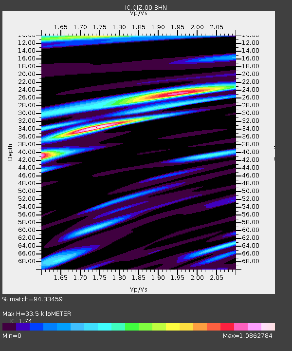
| Estimated Moho Depth: |
33.5 km |
| Estimated Crust Vp/Vs: |
1.74 |
| Assumed Crust Vp: |
6.182 km/s |
| Estimated Crust Vs: |
3.553 km/s |
| Estimated Crust Poisson's Ratio: |
0.25 |
|
| Radial Match: |
94.33459 % |
| Radial Bump: |
387 |
| Transverse Match: |
74.36716 % |
| Transverse Bump: |
400 |
| SOD ConfigId: |
2422 |
| Insert Time: |
2010-03-04 23:29:48.451 +0000 |
| GWidth: |
2.5 |
| Max Bumps: |
400 |
| Tol: |
0.001 |
|

Signal To Noise
| Channel | StoN | STA | LTA |
| IC:QIZ:00:BHN:20051015T10:14:01.786001Z | 11.008387 | 9.02553E-7 | 8.1987764E-8 |
| IC:QIZ:00:BHE:20051015T10:14:01.786001Z | 7.8633265 | 7.334513E-7 | 9.327494E-8 |
| IC:QIZ:00:BHZ:20051015T10:14:01.786001Z | 19.426643 | 2.0047112E-6 | 1.03193905E-7 |
| Arrivals |
| Ps | 4.3 SECOND |
| PpPs | 14 SECOND |
| PsPs/PpSs | 18 SECOND |


