You are here: Home > Network List > 7A - Mid-Atlantic Geophysical Integrative Collaboration Stations List
> Station CAKE Sugar Grove, West Virginia USA > Earthquake Result Viewer
CAKE Sugar Grove, West Virginia USA - Earthquake Result Viewer
| Earthquake location: |
Southern Alaska |
| Earthquake latitude/longitude: |
59.7/-153.5 |
| Earthquake time(UTC): |
2016/01/24 (024) 10:30:30 GMT |
| Earthquake Depth: |
128 km |
| Earthquake Magnitude: |
7.1 MWW, 6.4 ML |
| Earthquake Catalog/Contributor: |
NEIC PDE/NEIC COMCAT |
|
| Network: |
7A Mid-Atlantic Geophysical Integrative Collaboration |
| Station: |
CAKE Sugar Grove, West Virginia USA |
| Lat/Lon: |
38.52 N/79.30 W |
| Elevation: |
640 m |
|
| Distance: |
50.0 deg |
| Az: |
80.203 deg |
| Baz: |
320.376 deg |
| Ray Param: |
0.06791735 |
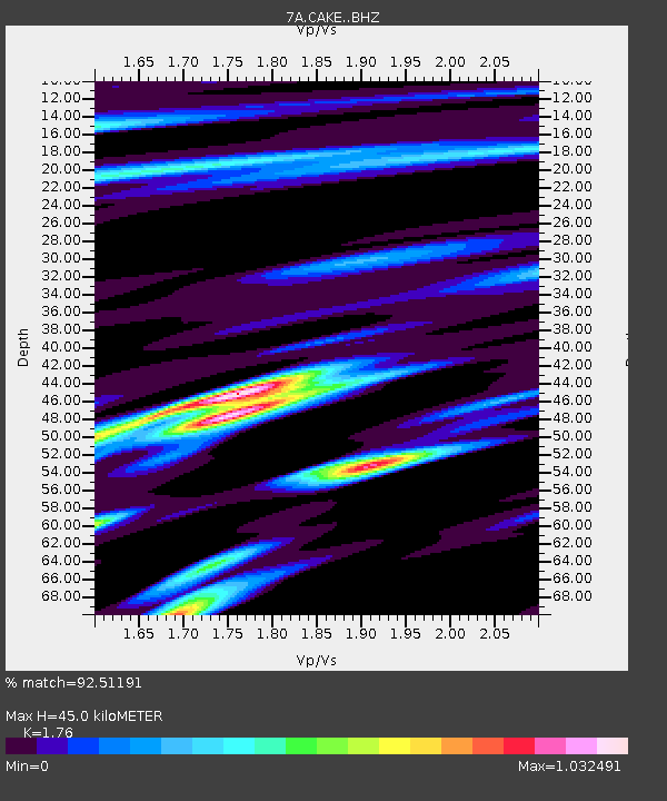
| Estimated Moho Depth: |
45.0 km |
| Estimated Crust Vp/Vs: |
1.76 |
| Assumed Crust Vp: |
6.159 km/s |
| Estimated Crust Vs: |
3.499 km/s |
| Estimated Crust Poisson's Ratio: |
0.26 |
|
| Radial Match: |
92.51191 % |
| Radial Bump: |
400 |
| Transverse Match: |
70.65182 % |
| Transverse Bump: |
400 |
| SOD ConfigId: |
7422571 |
| Insert Time: |
2019-04-21 19:38:10.677 +0000 |
| GWidth: |
2.5 |
| Max Bumps: |
400 |
| Tol: |
0.001 |
|

Signal To Noise
| Channel | StoN | STA | LTA |
| 7A:CAKE: :BHZ:20160124T10:38:39.960015Z | 1.5459529 | 1.2283958E-6 | 7.945881E-7 |
| 7A:CAKE: :BHN:20160124T10:38:39.960015Z | 2.8555949 | 1.8597411E-6 | 6.512622E-7 |
| 7A:CAKE: :BHE:20160124T10:38:39.960015Z | 0.610637 | 4.9144444E-7 | 8.048062E-7 |
| Arrivals |
| Ps | 5.9 SECOND |
| PpPs | 19 SECOND |
| PsPs/PpSs | 25 SECOND |


