You are here: Home > Network List > AZ - ANZA Regional Network Stations List
> Station TMSP TMSP, CA, USA > Earthquake Result Viewer
TMSP TMSP, CA, USA - Earthquake Result Viewer
| Earthquake location: |
Southern Alaska |
| Earthquake latitude/longitude: |
59.7/-153.5 |
| Earthquake time(UTC): |
2016/01/24 (024) 10:30:30 GMT |
| Earthquake Depth: |
128 km |
| Earthquake Magnitude: |
7.1 MWW, 6.4 ML |
| Earthquake Catalog/Contributor: |
NEIC PDE/NEIC COMCAT |
|
| Network: |
AZ ANZA Regional Network |
| Station: |
TMSP TMSP, CA, USA |
| Lat/Lon: |
33.62 N/116.68 W |
| Elevation: |
2077 m |
|
| Distance: |
35.5 deg |
| Az: |
120.658 deg |
| Baz: |
328.441 deg |
| Ray Param: |
0.07675602 |
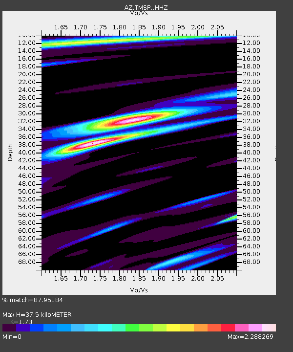
| Estimated Moho Depth: |
37.5 km |
| Estimated Crust Vp/Vs: |
1.73 |
| Assumed Crust Vp: |
6.264 km/s |
| Estimated Crust Vs: |
3.621 km/s |
| Estimated Crust Poisson's Ratio: |
0.25 |
|
| Radial Match: |
87.95184 % |
| Radial Bump: |
366 |
| Transverse Match: |
86.443565 % |
| Transverse Bump: |
400 |
| SOD ConfigId: |
7422571 |
| Insert Time: |
2019-04-21 19:38:39.814 +0000 |
| GWidth: |
2.5 |
| Max Bumps: |
400 |
| Tol: |
0.001 |
|

Signal To Noise
| Channel | StoN | STA | LTA |
| AZ:TMSP: :HHZ:20160124T10:36:43.25399Z | 7.163894 | 3.3474796E-6 | 4.6727095E-7 |
| AZ:TMSP: :HHN:20160124T10:36:43.25399Z | 3.1421506 | 2.1387975E-6 | 6.806795E-7 |
| AZ:TMSP: :HHE:20160124T10:36:43.25399Z | 2.921984 | 1.4709294E-6 | 5.0340094E-7 |
| Arrivals |
| Ps | 4.7 SECOND |
| PpPs | 15 SECOND |
| PsPs/PpSs | 20 SECOND |


