You are here: Home > Network List > CB - China National Seismic Network Stations List
> Station LZH Lanzhou,Gansu Province > Earthquake Result Viewer
LZH Lanzhou,Gansu Province - Earthquake Result Viewer
| Earthquake location: |
Southern Alaska |
| Earthquake latitude/longitude: |
59.7/-153.5 |
| Earthquake time(UTC): |
2016/01/24 (024) 10:30:30 GMT |
| Earthquake Depth: |
128 km |
| Earthquake Magnitude: |
7.1 MWW, 6.4 ML |
| Earthquake Catalog/Contributor: |
NEIC PDE/NEIC COMCAT |
|
| Network: |
CB China National Seismic Network |
| Station: |
LZH Lanzhou,Gansu Province |
| Lat/Lon: |
36.09 N/103.84 E |
| Elevation: |
1560 m |
|
| Distance: |
65.5 deg |
| Az: |
299.726 deg |
| Baz: |
32.976 deg |
| Ray Param: |
0.05788143 |
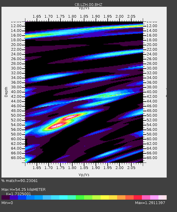
| Estimated Moho Depth: |
54.25 km |
| Estimated Crust Vp/Vs: |
1.73 |
| Assumed Crust Vp: |
6.306 km/s |
| Estimated Crust Vs: |
3.64 km/s |
| Estimated Crust Poisson's Ratio: |
0.25 |
|
| Radial Match: |
90.23061 % |
| Radial Bump: |
400 |
| Transverse Match: |
79.876816 % |
| Transverse Bump: |
400 |
| SOD ConfigId: |
7422571 |
| Insert Time: |
2019-04-21 19:39:01.843 +0000 |
| GWidth: |
2.5 |
| Max Bumps: |
400 |
| Tol: |
0.001 |
|

Signal To Noise
| Channel | StoN | STA | LTA |
| CB:LZH:00:BHZ:20160124T10:40:28.970024Z | 58.85856 | 8.288243E-6 | 1.4081628E-7 |
| CB:LZH:00:BHN:20160124T10:40:28.970024Z | 13.615671 | 2.8497266E-6 | 2.0929755E-7 |
| CB:LZH:00:BHE:20160124T10:40:28.970024Z | 12.725317 | 2.0631478E-6 | 1.6212938E-7 |
| Arrivals |
| Ps | 6.6 SECOND |
| PpPs | 23 SECOND |
| PsPs/PpSs | 29 SECOND |


