You are here: Home > Network List > CI - Caltech Regional Seismic Network Stations List
> Station ADO Adelanto Receiving Station, Victorville, CA, USA > Earthquake Result Viewer
ADO Adelanto Receiving Station, Victorville, CA, USA - Earthquake Result Viewer
| Earthquake location: |
Southern Alaska |
| Earthquake latitude/longitude: |
59.7/-153.5 |
| Earthquake time(UTC): |
2016/01/24 (024) 10:30:30 GMT |
| Earthquake Depth: |
128 km |
| Earthquake Magnitude: |
7.1 MWW, 6.4 ML |
| Earthquake Catalog/Contributor: |
NEIC PDE/NEIC COMCAT |
|
| Network: |
CI Caltech Regional Seismic Network |
| Station: |
ADO Adelanto Receiving Station, Victorville, CA, USA |
| Lat/Lon: |
34.55 N/117.43 W |
| Elevation: |
908 m |
|
| Distance: |
34.4 deg |
| Az: |
120.732 deg |
| Baz: |
328.083 deg |
| Ray Param: |
0.07735246 |
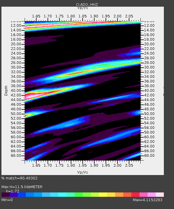
| Estimated Moho Depth: |
11.5 km |
| Estimated Crust Vp/Vs: |
1.72 |
| Assumed Crust Vp: |
6.276 km/s |
| Estimated Crust Vs: |
3.649 km/s |
| Estimated Crust Poisson's Ratio: |
0.24 |
|
| Radial Match: |
90.48302 % |
| Radial Bump: |
303 |
| Transverse Match: |
81.48896 % |
| Transverse Bump: |
400 |
| SOD ConfigId: |
7422571 |
| Insert Time: |
2019-04-21 19:39:11.180 +0000 |
| GWidth: |
2.5 |
| Max Bumps: |
400 |
| Tol: |
0.001 |
|

Signal To Noise
| Channel | StoN | STA | LTA |
| CI:ADO: :HHZ:20160124T10:36:33.678002Z | 8.18053 | 3.6589413E-6 | 4.4727437E-7 |
| CI:ADO: :HHN:20160124T10:36:33.678002Z | 2.6109293 | 2.8258546E-6 | 1.0823176E-6 |
| CI:ADO: :HHE:20160124T10:36:33.678002Z | 1.1854068 | 1.0478607E-6 | 8.8396706E-7 |
| Arrivals |
| Ps | 1.4 SECOND |
| PpPs | 4.6 SECOND |
| PsPs/PpSs | 6.0 SECOND |


