You are here: Home > Network List > CI - Caltech Regional Seismic Network Stations List
> Station BAR Barrett, Tecate, CA, USA > Earthquake Result Viewer
BAR Barrett, Tecate, CA, USA - Earthquake Result Viewer
| Earthquake location: |
Southern Alaska |
| Earthquake latitude/longitude: |
59.7/-153.5 |
| Earthquake time(UTC): |
2016/01/24 (024) 10:30:30 GMT |
| Earthquake Depth: |
128 km |
| Earthquake Magnitude: |
7.1 MWW, 6.4 ML |
| Earthquake Catalog/Contributor: |
NEIC PDE/NEIC COMCAT |
|
| Network: |
CI Caltech Regional Seismic Network |
| Station: |
BAR Barrett, Tecate, CA, USA |
| Lat/Lon: |
32.68 N/116.67 W |
| Elevation: |
521 m |
|
| Distance: |
36.3 deg |
| Az: |
121.475 deg |
| Baz: |
329.108 deg |
| Ray Param: |
0.07632155 |
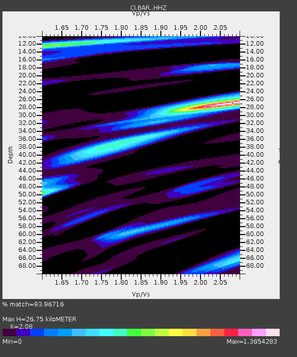
| Estimated Moho Depth: |
26.75 km |
| Estimated Crust Vp/Vs: |
2.08 |
| Assumed Crust Vp: |
6.264 km/s |
| Estimated Crust Vs: |
3.011 km/s |
| Estimated Crust Poisson's Ratio: |
0.35 |
|
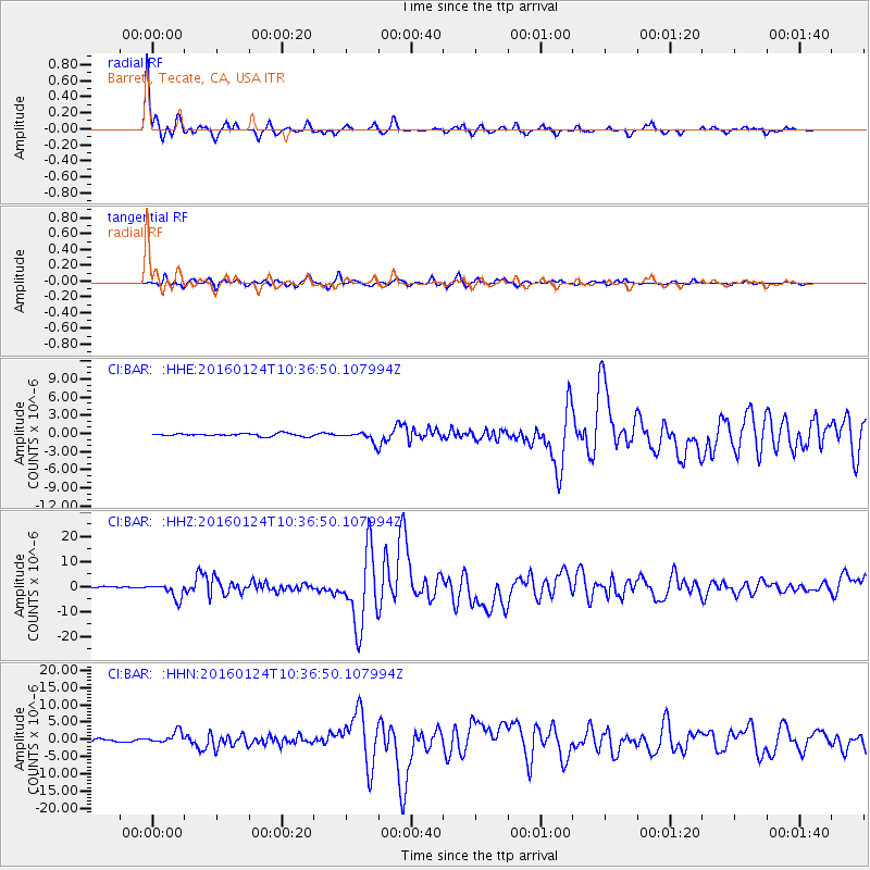
| Radial Match: |
93.96716 % |
| Radial Bump: |
237 |
| Transverse Match: |
81.41016 % |
| Transverse Bump: |
400 |
| SOD ConfigId: |
7422571 |
| Insert Time: |
2019-04-21 19:39:13.545 +0000 |
| GWidth: |
2.5 |
| Max Bumps: |
400 |
| Tol: |
0.001 |
|
Signal To Noise
| Channel | StoN | STA | LTA |
| CI:BAR: :HHZ:20160124T10:36:50.107994Z | 8.092913 | 3.150848E-6 | 3.8933425E-7 |
| CI:BAR: :HHN:20160124T10:36:50.107994Z | 5.976927 | 1.7210733E-6 | 2.8795287E-7 |
| CI:BAR: :HHE:20160124T10:36:50.107994Z | 4.8531904 | 1.1149652E-6 | 2.297386E-7 |
| Arrivals |
| Ps | 4.9 SECOND |
| PpPs | 12 SECOND |
| PsPs/PpSs | 17 SECOND |


