You are here: Home > Network List > IC - New China Digital Seismograph Network Stations List
> Station QIZ Qiongzhong, Guangduong Province, China > Earthquake Result Viewer
QIZ Qiongzhong, Guangduong Province, China - Earthquake Result Viewer

| Earthquake location: |
Macquarie Island Region |
| Earthquake latitude/longitude: |
-55.7/158.5 |
| Earthquake time(UTC): |
2008/04/12 (103) 00:30:12 GMT |
| Earthquake Depth: |
16 km |
| Earthquake Magnitude: |
6.8 MB, 7.1 MS, 7.1 MW, 7.1 MW |
| Earthquake Catalog/Contributor: |
WHDF/NEIC |
|
| Network: |
IC New China Digital Seismograph Network |
| Station: |
QIZ Qiongzhong, Guangduong Province, China |
| Lat/Lon: |
19.03 N/109.84 E |
| Elevation: |
230 m |
|
| Distance: |
85.0 deg |
| Az: |
314.565 deg |
| Baz: |
154.74 deg |
| Ray Param: |
0.045077577 |
| Estimated Moho Depth: |
30.75 km |
| Estimated Crust Vp/Vs: |
1.78 |
| Assumed Crust Vp: |
6.182 km/s |
| Estimated Crust Vs: |
3.473 km/s |
| Estimated Crust Poisson's Ratio: |
0.27 |
|
| Radial Match: |
96.39564 % |
| Radial Bump: |
361 |
| Transverse Match: |
89.72475 % |
| Transverse Bump: |
400 |
| SOD ConfigId: |
2504 |
| Insert Time: |
2010-03-04 23:30:39.457 +0000 |
| GWidth: |
2.5 |
| Max Bumps: |
400 |
| Tol: |
0.001 |
|
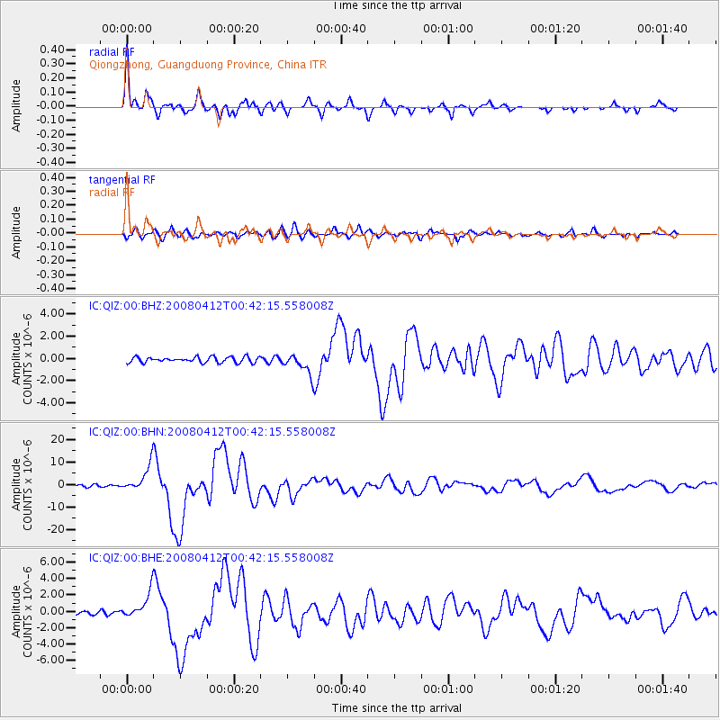
Signal To Noise
| Channel | StoN | STA | LTA |
| IC:QIZ:00:BHN:20080412T00:42:15.558008Z | 17.07673 | 5.9547356E-6 | 3.4870467E-7 |
| IC:QIZ:00:BHE:20080412T00:42:15.558008Z | 10.627119 | 1.6242021E-6 | 1.5283561E-7 |
| IC:QIZ:00:BHZ:20080412T00:42:15.558008Z | 3.6670802 | 9.1585423E-7 | 2.4975026E-7 |
| Arrivals |
| Ps | 4.0 SECOND |
| PpPs | 14 SECOND |
| PsPs/PpSs | 17 SECOND |


