You are here: Home > Network List > CI - Caltech Regional Seismic Network Stations List
> Station MUR Murrieta > Earthquake Result Viewer
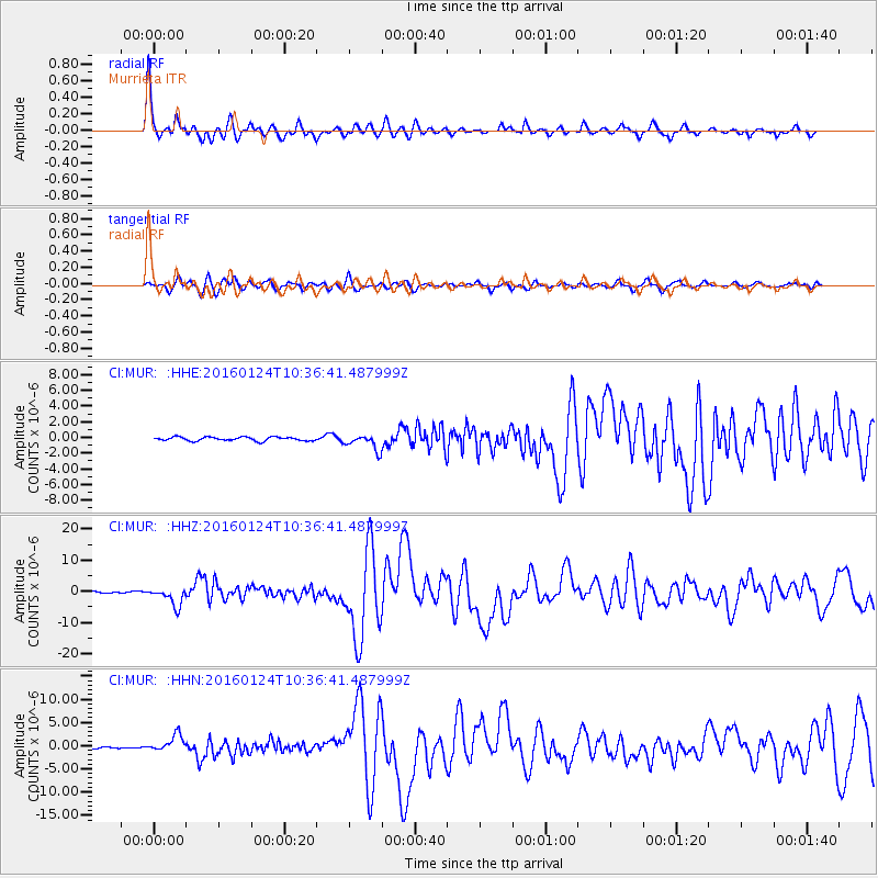
MUR Murrieta - Earthquake Result Viewer

| Earthquake location: |
Southern Alaska |
| Earthquake latitude/longitude: |
59.7/-153.5 |
| Earthquake time(UTC): |
2016/01/24 (024) 10:30:30 GMT |
| Earthquake Depth: |
128 km |
| Earthquake Magnitude: |
7.1 MWW, 6.4 ML |
| Earthquake Catalog/Contributor: |
NEIC PDE/NEIC COMCAT |
|
| Network: |
CI Caltech Regional Seismic Network |
| Station: |
MUR Murrieta |
| Lat/Lon: |
33.60 N/117.20 W |
| Elevation: |
562 m |
|
| Distance: |
35.3 deg |
| Az: |
121.307 deg |
| Baz: |
328.688 deg |
| Ray Param: |
0.0768681 |
| Estimated Moho Depth: |
68.75 km |
| Estimated Crust Vp/Vs: |
2.08 |
| Assumed Crust Vp: |
6.264 km/s |
| Estimated Crust Vs: |
3.019 km/s |
| Estimated Crust Poisson's Ratio: |
0.35 |
|
| Radial Match: |
93.997665 % |
| Radial Bump: |
363 |
| Transverse Match: |
80.82087 % |
| Transverse Bump: |
400 |
| SOD ConfigId: |
7422571 |
| Insert Time: |
2019-04-21 19:39:41.652 +0000 |
| GWidth: |
2.5 |
| Max Bumps: |
400 |
| Tol: |
0.001 |
|
Signal To Noise
| Channel | StoN | STA | LTA |
| CI:MUR: :HHZ:20160124T10:36:41.487999Z | 12.425556 | 2.9289884E-6 | 2.3572292E-7 |
| CI:MUR: :HHN:20160124T10:36:41.487999Z | 5.355323 | 1.794439E-6 | 3.3507575E-7 |
| CI:MUR: :HHE:20160124T10:36:41.487999Z | 4.2137065 | 1.0209131E-6 | 2.4228387E-7 |
| Arrivals |
| Ps | 13 SECOND |
| PpPs | 32 SECOND |
| PsPs/PpSs | 44 SECOND |


