You are here: Home > Network List > CI - Caltech Regional Seismic Network Stations List
> Station VES Vestal, Richgrove, CA, USA > Earthquake Result Viewer
VES Vestal, Richgrove, CA, USA - Earthquake Result Viewer
| Earthquake location: |
Southern Alaska |
| Earthquake latitude/longitude: |
59.7/-153.5 |
| Earthquake time(UTC): |
2016/01/24 (024) 10:30:30 GMT |
| Earthquake Depth: |
128 km |
| Earthquake Magnitude: |
7.1 MWW, 6.4 ML |
| Earthquake Catalog/Contributor: |
NEIC PDE/NEIC COMCAT |
|
| Network: |
CI Caltech Regional Seismic Network |
| Station: |
VES Vestal, Richgrove, CA, USA |
| Lat/Lon: |
35.84 N/119.08 W |
| Elevation: |
154 m |
|
| Distance: |
32.6 deg |
| Az: |
121.572 deg |
| Baz: |
327.836 deg |
| Ray Param: |
0.07822639 |
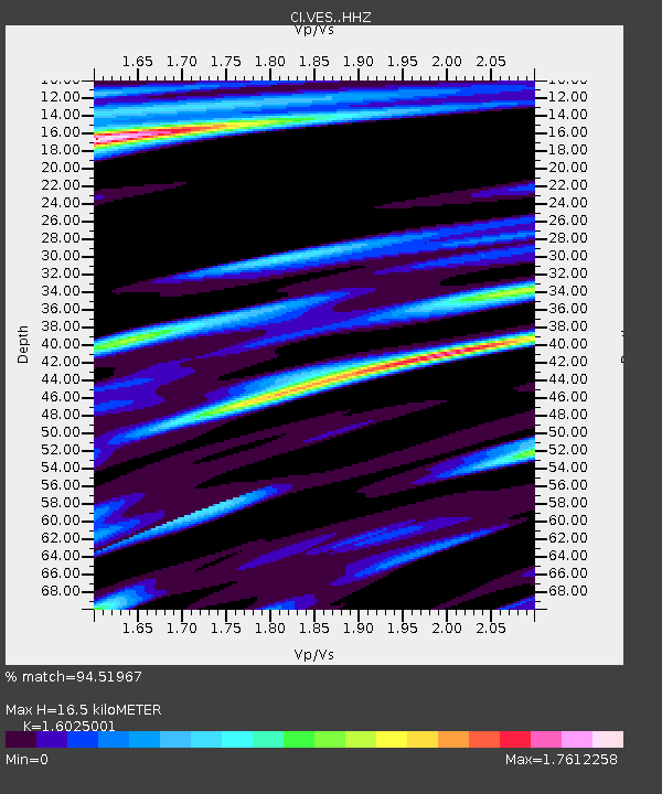
| Estimated Moho Depth: |
16.5 km |
| Estimated Crust Vp/Vs: |
1.60 |
| Assumed Crust Vp: |
6.1 km/s |
| Estimated Crust Vs: |
3.807 km/s |
| Estimated Crust Poisson's Ratio: |
0.18 |
|
| Radial Match: |
94.51967 % |
| Radial Bump: |
369 |
| Transverse Match: |
88.93908 % |
| Transverse Bump: |
330 |
| SOD ConfigId: |
7422571 |
| Insert Time: |
2019-04-21 19:40:02.283 +0000 |
| GWidth: |
2.5 |
| Max Bumps: |
400 |
| Tol: |
0.001 |
|

Signal To Noise
| Channel | StoN | STA | LTA |
| CI:VES: :HHZ:20160124T10:36:18.037987Z | 25.167107 | 5.057214E-6 | 2.009454E-7 |
| CI:VES: :HHN:20160124T10:36:18.037987Z | 4.2861757 | 2.6024518E-6 | 6.071734E-7 |
| CI:VES: :HHE:20160124T10:36:18.037987Z | 2.121503 | 2.124741E-6 | 1.0015262E-6 |
| Arrivals |
| Ps | 1.8 SECOND |
| PpPs | 6.5 SECOND |
| PsPs/PpSs | 8.3 SECOND |


