You are here: Home > Network List > DK - Danish Seismological Network Stations List
> Station ANGG Tasiilaq, Greenland > Earthquake Result Viewer
ANGG Tasiilaq, Greenland - Earthquake Result Viewer
| Earthquake location: |
Southern Alaska |
| Earthquake latitude/longitude: |
59.7/-153.5 |
| Earthquake time(UTC): |
2016/01/24 (024) 10:30:30 GMT |
| Earthquake Depth: |
128 km |
| Earthquake Magnitude: |
7.1 MWW, 6.4 ML |
| Earthquake Catalog/Contributor: |
NEIC PDE/NEIC COMCAT |
|
| Network: |
DK Danish Seismological Network |
| Station: |
ANGG Tasiilaq, Greenland |
| Lat/Lon: |
65.62 N/37.64 W |
| Elevation: |
9.0 m |
|
| Distance: |
46.2 deg |
| Az: |
31.178 deg |
| Baz: |
320.722 deg |
| Ray Param: |
0.070339955 |
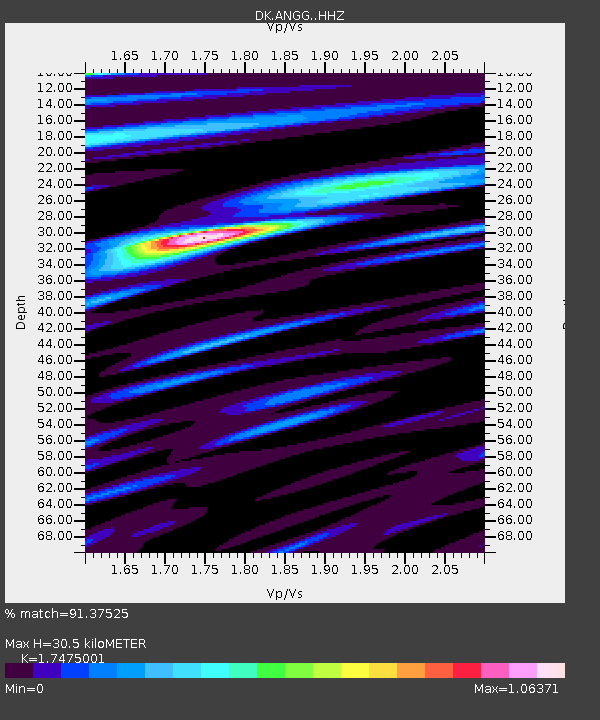
| Estimated Moho Depth: |
30.5 km |
| Estimated Crust Vp/Vs: |
1.75 |
| Assumed Crust Vp: |
6.24 km/s |
| Estimated Crust Vs: |
3.571 km/s |
| Estimated Crust Poisson's Ratio: |
0.26 |
|
| Radial Match: |
91.37525 % |
| Radial Bump: |
400 |
| Transverse Match: |
74.14203 % |
| Transverse Bump: |
400 |
| SOD ConfigId: |
7422571 |
| Insert Time: |
2019-04-21 19:40:25.185 +0000 |
| GWidth: |
2.5 |
| Max Bumps: |
400 |
| Tol: |
0.001 |
|

Signal To Noise
| Channel | StoN | STA | LTA |
| DK:ANGG: :HHZ:20160124T10:38:11.468987Z | 5.12132 | 3.591682E-6 | 7.013196E-7 |
| DK:ANGG: :HHN:20160124T10:38:11.468987Z | 3.043749 | 1.5158902E-6 | 4.980339E-7 |
| DK:ANGG: :HHE:20160124T10:38:11.468987Z | 3.1414757 | 1.7503456E-6 | 5.5717305E-7 |
| Arrivals |
| Ps | 3.9 SECOND |
| PpPs | 13 SECOND |
| PsPs/PpSs | 17 SECOND |


