You are here: Home > Network List > EI - Irish National Seismic Network (INSN) Stations List
> Station IGLA GLENGOWLA, CO GALWAY, IRELAND > Earthquake Result Viewer
IGLA GLENGOWLA, CO GALWAY, IRELAND - Earthquake Result Viewer
| Earthquake location: |
Southern Alaska |
| Earthquake latitude/longitude: |
59.7/-153.5 |
| Earthquake time(UTC): |
2016/01/24 (024) 10:30:30 GMT |
| Earthquake Depth: |
128 km |
| Earthquake Magnitude: |
7.1 MWW, 6.4 ML |
| Earthquake Catalog/Contributor: |
NEIC PDE/NEIC COMCAT |
|
| Network: |
EI Irish National Seismic Network (INSN) |
| Station: |
IGLA GLENGOWLA, CO GALWAY, IRELAND |
| Lat/Lon: |
53.42 N/9.38 W |
| Elevation: |
31 m |
|
| Distance: |
63.6 deg |
| Az: |
23.075 deg |
| Baz: |
340.583 deg |
| Ray Param: |
0.059083797 |
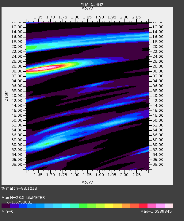
| Estimated Moho Depth: |
28.5 km |
| Estimated Crust Vp/Vs: |
1.68 |
| Assumed Crust Vp: |
6.276 km/s |
| Estimated Crust Vs: |
3.747 km/s |
| Estimated Crust Poisson's Ratio: |
0.22 |
|
| Radial Match: |
88.1018 % |
| Radial Bump: |
338 |
| Transverse Match: |
56.730923 % |
| Transverse Bump: |
399 |
| SOD ConfigId: |
7422571 |
| Insert Time: |
2019-04-21 19:40:41.353 +0000 |
| GWidth: |
2.5 |
| Max Bumps: |
400 |
| Tol: |
0.001 |
|

Signal To Noise
| Channel | StoN | STA | LTA |
| EI:IGLA: :HHZ:20160124T10:40:16.55999Z | 3.862854 | 4.005525E-6 | 1.0369341E-6 |
| EI:IGLA: :HHN:20160124T10:40:16.55999Z | 1.9766227 | 1.3749105E-6 | 6.9558575E-7 |
| EI:IGLA: :HHE:20160124T10:40:16.55999Z | 0.61445934 | 5.982633E-7 | 9.736418E-7 |
| Arrivals |
| Ps | 3.2 SECOND |
| PpPs | 12 SECOND |
| PsPs/PpSs | 15 SECOND |


