You are here: Home > Network List > GS - US Geological Survey Networks Stations List
> Station DEC06 Boomer, Decatur, IL, USA > Earthquake Result Viewer
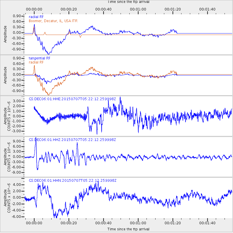
DEC06 Boomer, Decatur, IL, USA - Earthquake Result Viewer
*The percent match for this event was below the threshold and hence no stack was calculated.
| Earthquake location: |
Kuril Islands |
| Earthquake latitude/longitude: |
44.0/147.9 |
| Earthquake time(UTC): |
2015/07/07 (188) 05:10:27 GMT |
| Earthquake Depth: |
38 km |
| Earthquake Magnitude: |
6.3 MO |
| Earthquake Catalog/Contributor: |
NEIC PDE/NEIC ALERT |
|
| Network: |
GS US Geological Survey Networks |
| Station: |
DEC06 Boomer, Decatur, IL, USA |
| Lat/Lon: |
39.90 N/88.95 W |
| Elevation: |
215 m |
|
| Distance: |
82.0 deg |
| Az: |
40.59 deg |
| Baz: |
322.376 deg |
| Ray Param: |
$rayparam |
*The percent match for this event was below the threshold and hence was not used in the summary stack. |
|
| Radial Match: |
42.043507 % |
| Radial Bump: |
400 |
| Transverse Match: |
52.38868 % |
| Transverse Bump: |
400 |
| SOD ConfigId: |
976571 |
| Insert Time: |
2015-07-21 05:29:50.687 +0000 |
| GWidth: |
2.5 |
| Max Bumps: |
400 |
| Tol: |
0.001 |
|
Signal To Noise
| Channel | StoN | STA | LTA |
| GS:DEC06:01:HHZ:20150707T05:22:12.259998Z | 33.211777 | 4.4415096E-6 | 1.3373297E-7 |
| GS:DEC06:01:HHN:20150707T05:22:12.259998Z | 1.5312254 | 2.1118935E-6 | 1.3792179E-6 |
| GS:DEC06:01:HHE:20150707T05:22:12.259998Z | 2.407156 | 1.5052156E-6 | 6.253087E-7 |
| Arrivals |
| Ps | |
| PpPs | |
| PsPs/PpSs | |


