You are here: Home > Network List > GS - US Geological Survey Networks Stations List
> Station DEC07 Decatur Surface Seismic Site, Decatur, IL, USA > Earthquake Result Viewer
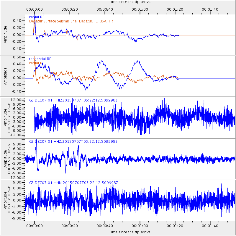
DEC07 Decatur Surface Seismic Site, Decatur, IL, USA - Earthquake Result Viewer
*The percent match for this event was below the threshold and hence no stack was calculated.
| Earthquake location: |
Kuril Islands |
| Earthquake latitude/longitude: |
44.0/147.9 |
| Earthquake time(UTC): |
2015/07/07 (188) 05:10:27 GMT |
| Earthquake Depth: |
38 km |
| Earthquake Magnitude: |
6.3 MO |
| Earthquake Catalog/Contributor: |
NEIC PDE/NEIC ALERT |
|
| Network: |
GS US Geological Survey Networks |
| Station: |
DEC07 Decatur Surface Seismic Site, Decatur, IL, USA |
| Lat/Lon: |
39.86 N/88.90 W |
| Elevation: |
212 m |
|
| Distance: |
82.1 deg |
| Az: |
40.58 deg |
| Baz: |
322.405 deg |
| Ray Param: |
$rayparam |
*The percent match for this event was below the threshold and hence was not used in the summary stack. |
|
| Radial Match: |
72.459724 % |
| Radial Bump: |
400 |
| Transverse Match: |
36.150303 % |
| Transverse Bump: |
400 |
| SOD ConfigId: |
976571 |
| Insert Time: |
2015-07-21 05:29:51.652 +0000 |
| GWidth: |
2.5 |
| Max Bumps: |
400 |
| Tol: |
0.001 |
|
Signal To Noise
| Channel | StoN | STA | LTA |
| GS:DEC07:01:HHZ:20150707T05:22:12.509998Z | 4.443003 | 4.573884E-6 | 1.0294576E-6 |
| GS:DEC07:01:HHN:20150707T05:22:12.509998Z | 1.0332761 | 3.0848169E-6 | 2.985472E-6 |
| GS:DEC07:01:HHE:20150707T05:22:12.509998Z | 1.0659119 | 4.3852624E-6 | 4.1140947E-6 |
| Arrivals |
| Ps | |
| PpPs | |
| PsPs/PpSs | |


