You are here: Home > Network List > GB - Great Britain Seismograph Network Stations List
> Station KPL PLOCKTON, SCOTLAND > Earthquake Result Viewer
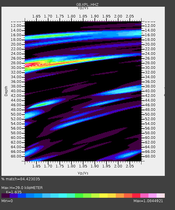
KPL PLOCKTON, SCOTLAND - Earthquake Result Viewer
| Earthquake location: |
Southern Alaska |
| Earthquake latitude/longitude: |
59.7/-153.5 |
| Earthquake time(UTC): |
2016/01/24 (024) 10:30:30 GMT |
| Earthquake Depth: |
128 km |
| Earthquake Magnitude: |
7.1 MWW, 6.4 ML |
| Earthquake Catalog/Contributor: |
NEIC PDE/NEIC COMCAT |
|
| Network: |
GB Great Britain Seismograph Network |
| Station: |
KPL PLOCKTON, SCOTLAND |
| Lat/Lon: |
57.34 N/5.65 W |
| Elevation: |
13 m |
|
| Distance: |
60.6 deg |
| Az: |
19.37 deg |
| Baz: |
341.908 deg |
| Ray Param: |
0.06104521 |
| Estimated Moho Depth: |
29.0 km |
| Estimated Crust Vp/Vs: |
1.63 |
| Assumed Crust Vp: |
6.276 km/s |
| Estimated Crust Vs: |
3.838 km/s |
| Estimated Crust Poisson's Ratio: |
0.20 |
|
| Radial Match: |
84.423035 % |
| Radial Bump: |
342 |
| Transverse Match: |
45.957443 % |
| Transverse Bump: |
400 |
| SOD ConfigId: |
7422571 |
| Insert Time: |
2019-04-21 19:41:00.714 +0000 |
| GWidth: |
2.5 |
| Max Bumps: |
400 |
| Tol: |
0.001 |
|

Signal To Noise
| Channel | StoN | STA | LTA |
| GB:KPL: :HHZ:20160124T10:39:56.379998Z | 2.1500459 | 2.9635858E-6 | 1.3783824E-6 |
| GB:KPL: :HHN:20160124T10:39:56.379998Z | 1.9236898 | 1.6278592E-6 | 8.4621706E-7 |
| GB:KPL: :HHE:20160124T10:39:56.379998Z | 1.7070339 | 1.8717373E-6 | 1.0964852E-6 |
| Arrivals |
| Ps | 3.1 SECOND |
| PpPs | 12 SECOND |
| PsPs/PpSs | 15 SECOND |


