You are here: Home > Network List > GS - US Geological Survey Networks Stations List
> Station DEC12 Decatur Surface Seismic Site, Decatur, IL, USA > Earthquake Result Viewer
DEC12 Decatur Surface Seismic Site, Decatur, IL, USA - Earthquake Result Viewer

| Earthquake location: |
Kuril Islands |
| Earthquake latitude/longitude: |
44.0/147.9 |
| Earthquake time(UTC): |
2015/07/07 (188) 05:10:27 GMT |
| Earthquake Depth: |
38 km |
| Earthquake Magnitude: |
6.3 MO |
| Earthquake Catalog/Contributor: |
NEIC PDE/NEIC ALERT |
|
| Network: |
GS US Geological Survey Networks |
| Station: |
DEC12 Decatur Surface Seismic Site, Decatur, IL, USA |
| Lat/Lon: |
39.91 N/88.91 W |
| Elevation: |
208 m |
|
| Distance: |
82.0 deg |
| Az: |
40.559 deg |
| Baz: |
322.397 deg |
| Ray Param: |
0.04710976 |
| Estimated Moho Depth: |
50.25 km |
| Estimated Crust Vp/Vs: |
1.74 |
| Assumed Crust Vp: |
6.444 km/s |
| Estimated Crust Vs: |
3.714 km/s |
| Estimated Crust Poisson's Ratio: |
0.25 |
|
| Radial Match: |
80.650444 % |
| Radial Bump: |
400 |
| Transverse Match: |
51.67598 % |
| Transverse Bump: |
400 |
| SOD ConfigId: |
976571 |
| Insert Time: |
2015-07-21 05:30:00.923 +0000 |
| GWidth: |
2.5 |
| Max Bumps: |
400 |
| Tol: |
0.001 |
|
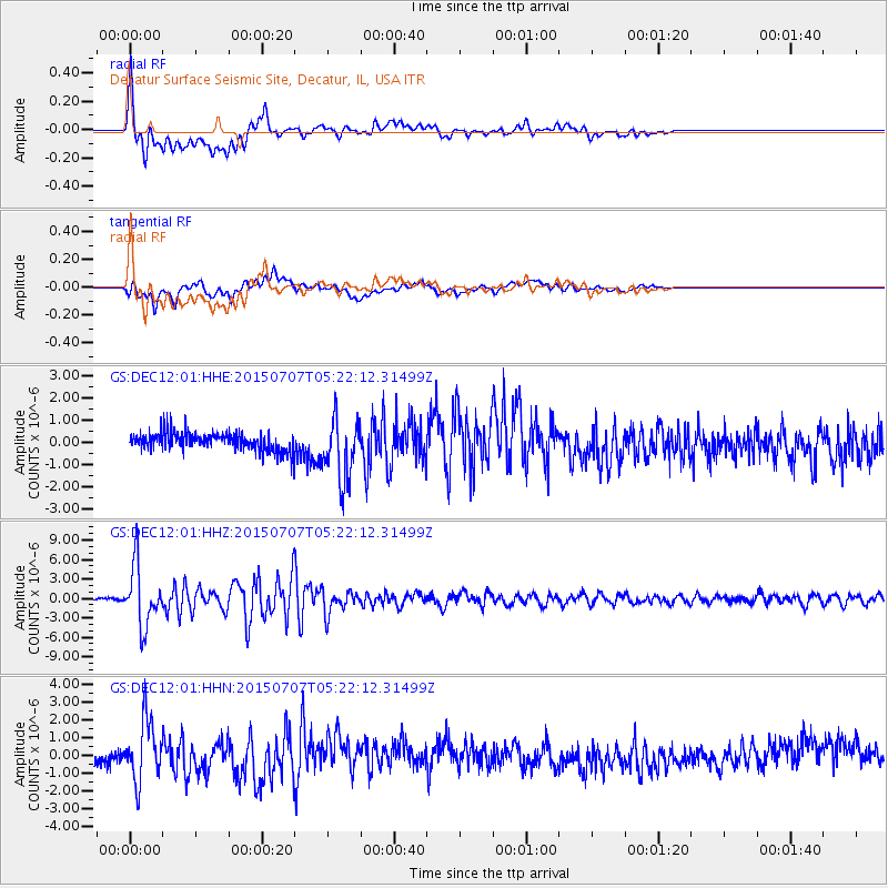
Signal To Noise
| Channel | StoN | STA | LTA |
| GS:DEC12:01:HHZ:20150707T05:22:12.31499Z | 24.794258 | 4.6955097E-6 | 1.8937891E-7 |
| GS:DEC12:01:HHN:20150707T05:22:12.31499Z | 3.6014993 | 1.688918E-6 | 4.6894857E-7 |
| GS:DEC12:01:HHE:20150707T05:22:12.31499Z | 3.4776542 | 1.4012415E-6 | 4.0292724E-7 |
| Arrivals |
| Ps | 5.9 SECOND |
| PpPs | 21 SECOND |
| PsPs/PpSs | 27 SECOND |


