You are here: Home > Network List > JP - Japan Meteorological Agency Seismic Network Stations List
> Station JMM Miyagi Marumori > Earthquake Result Viewer
JMM Miyagi Marumori - Earthquake Result Viewer
| Earthquake location: |
Southern Alaska |
| Earthquake latitude/longitude: |
59.7/-153.5 |
| Earthquake time(UTC): |
2016/01/24 (024) 10:30:30 GMT |
| Earthquake Depth: |
128 km |
| Earthquake Magnitude: |
7.1 MWW, 6.4 ML |
| Earthquake Catalog/Contributor: |
NEIC PDE/NEIC COMCAT |
|
| Network: |
JP Japan Meteorological Agency Seismic Network |
| Station: |
JMM Miyagi Marumori |
| Lat/Lon: |
37.87 N/140.79 E |
| Elevation: |
100 m |
|
| Distance: |
46.2 deg |
| Az: |
272.411 deg |
| Baz: |
39.861 deg |
| Ray Param: |
0.07031937 |
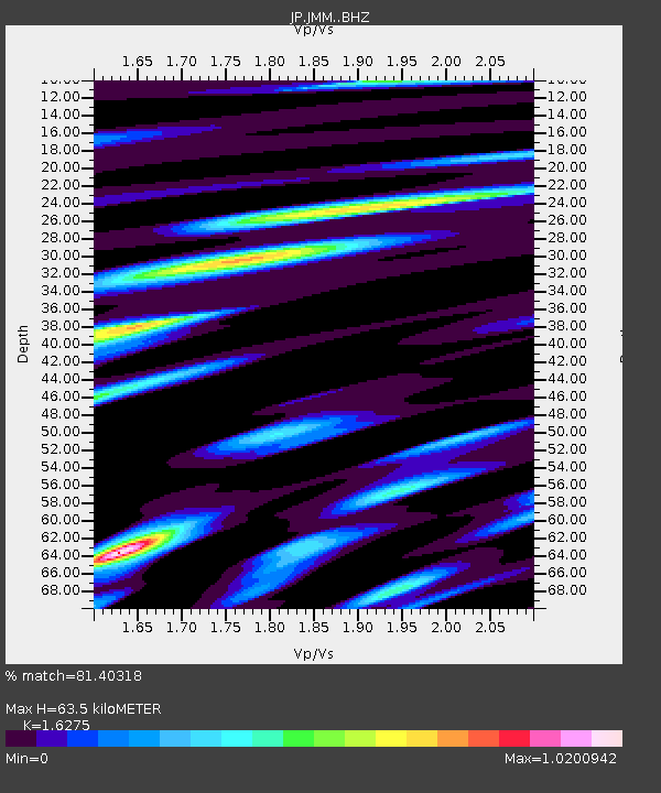
| Estimated Moho Depth: |
63.5 km |
| Estimated Crust Vp/Vs: |
1.63 |
| Assumed Crust Vp: |
6.24 km/s |
| Estimated Crust Vs: |
3.834 km/s |
| Estimated Crust Poisson's Ratio: |
0.20 |
|
| Radial Match: |
81.40318 % |
| Radial Bump: |
400 |
| Transverse Match: |
81.33422 % |
| Transverse Bump: |
400 |
| SOD ConfigId: |
7422571 |
| Insert Time: |
2019-04-21 19:42:16.465 +0000 |
| GWidth: |
2.5 |
| Max Bumps: |
400 |
| Tol: |
0.001 |
|

Signal To Noise
| Channel | StoN | STA | LTA |
| JP:JMM: :BHZ:20160124T10:38:12.149987Z | 9.72049 | 1.35237215E-5 | 1.391259E-6 |
| JP:JMM: :BHN:20160124T10:38:12.149987Z | 6.327516 | 6.8681084E-6 | 1.0854351E-6 |
| JP:JMM: :BHE:20160124T10:38:12.149987Z | 6.210936 | 7.372289E-6 | 1.1869852E-6 |
| Arrivals |
| Ps | 6.8 SECOND |
| PpPs | 25 SECOND |
| PsPs/PpSs | 32 SECOND |


