You are here: Home > Network List > IC - New China Digital Seismograph Network Stations List
> Station QIZ Qiongzhong, Guangduong Province, China > Earthquake Result Viewer
QIZ Qiongzhong, Guangduong Province, China - Earthquake Result Viewer
| Earthquake location: |
Tonga Islands |
| Earthquake latitude/longitude: |
-21.9/-173.8 |
| Earthquake time(UTC): |
2008/10/19 (293) 05:10:33 GMT |
| Earthquake Depth: |
29 km |
| Earthquake Magnitude: |
6.8 MB, 7.0 MS, 6.9 MW, 6.9 MW |
| Earthquake Catalog/Contributor: |
WHDF/NEIC |
|
| Network: |
IC New China Digital Seismograph Network |
| Station: |
QIZ Qiongzhong, Guangduong Province, China |
| Lat/Lon: |
19.03 N/109.84 E |
| Elevation: |
230 m |
|
| Distance: |
85.0 deg |
| Az: |
292.661 deg |
| Baz: |
115.024 deg |
| Ray Param: |
0.045060933 |
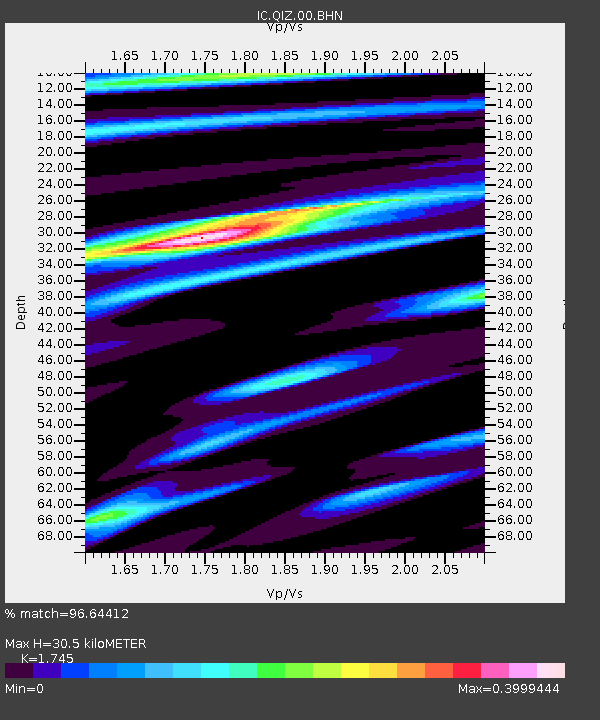
| Estimated Moho Depth: |
30.5 km |
| Estimated Crust Vp/Vs: |
1.75 |
| Assumed Crust Vp: |
6.182 km/s |
| Estimated Crust Vs: |
3.543 km/s |
| Estimated Crust Poisson's Ratio: |
0.26 |
|
| Radial Match: |
96.64412 % |
| Radial Bump: |
381 |
| Transverse Match: |
86.44291 % |
| Transverse Bump: |
400 |
| SOD ConfigId: |
2556 |
| Insert Time: |
2010-03-04 23:31:29.897 +0000 |
| GWidth: |
2.5 |
| Max Bumps: |
400 |
| Tol: |
0.001 |
|
Signal To Noise
| Channel | StoN | STA | LTA |
| IC:QIZ:00:BHN:20081019T05:22:35.110012Z | 14.947566 | 3.1978727E-6 | 2.1393936E-7 |
| IC:QIZ:00:BHE:20081019T05:22:35.110012Z | 2.5070703 | 3.9607255E-7 | 1.5798223E-7 |
| IC:QIZ:00:BHZ:20081019T05:22:35.110012Z | 9.049034 | 4.9479166E-7 | 5.4678942E-8 |
| Arrivals |
| Ps | 3.8 SECOND |
| PpPs | 13 SECOND |
| PsPs/PpSs | 17 SECOND |


