You are here: Home > Network List > KN - Kyrgyz Seismic Telemetry Network Stations List
> Station AML - > Earthquake Result Viewer
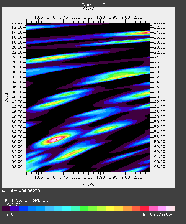
AML - - Earthquake Result Viewer
| Earthquake location: |
Southern Alaska |
| Earthquake latitude/longitude: |
59.7/-153.5 |
| Earthquake time(UTC): |
2016/01/24 (024) 10:30:30 GMT |
| Earthquake Depth: |
128 km |
| Earthquake Magnitude: |
7.1 MWW, 6.4 ML |
| Earthquake Catalog/Contributor: |
NEIC PDE/NEIC COMCAT |
|
| Network: |
KN Kyrgyz Seismic Telemetry Network |
| Station: |
AML - |
| Lat/Lon: |
42.13 N/73.69 E |
| Elevation: |
3400 m |
|
| Distance: |
71.4 deg |
| Az: |
324.875 deg |
| Baz: |
23.122 deg |
| Ray Param: |
0.054022856 |
| Estimated Moho Depth: |
56.75 km |
| Estimated Crust Vp/Vs: |
1.72 |
| Assumed Crust Vp: |
6.316 km/s |
| Estimated Crust Vs: |
3.672 km/s |
| Estimated Crust Poisson's Ratio: |
0.24 |
|
| Radial Match: |
94.86278 % |
| Radial Bump: |
400 |
| Transverse Match: |
86.28704 % |
| Transverse Bump: |
400 |
| SOD ConfigId: |
7422571 |
| Insert Time: |
2019-04-21 19:42:26.425 +0000 |
| GWidth: |
2.5 |
| Max Bumps: |
400 |
| Tol: |
0.001 |
|

Signal To Noise
| Channel | StoN | STA | LTA |
| KN:AML: :HHZ:20160124T10:41:05.539971Z | 53.979965 | 4.6054697E-6 | 8.531813E-8 |
| KN:AML: :HHN:20160124T10:41:05.539971Z | 20.888552 | 1.6915026E-6 | 8.0977486E-8 |
| KN:AML: :HHE:20160124T10:41:05.539971Z | 12.534393 | 8.724355E-7 | 6.960333E-8 |
| Arrivals |
| Ps | 6.7 SECOND |
| PpPs | 24 SECOND |
| PsPs/PpSs | 30 SECOND |


