You are here: Home > Network List > KN - Kyrgyz Seismic Telemetry Network Stations List
> Station ULHL - > Earthquake Result Viewer
ULHL - - Earthquake Result Viewer
*The percent match for this event was below the threshold and hence no stack was calculated.
| Earthquake location: |
Southern Alaska |
| Earthquake latitude/longitude: |
59.7/-153.5 |
| Earthquake time(UTC): |
2016/01/24 (024) 10:30:30 GMT |
| Earthquake Depth: |
128 km |
| Earthquake Magnitude: |
7.1 MWW, 6.4 ML |
| Earthquake Catalog/Contributor: |
NEIC PDE/NEIC COMCAT |
|
| Network: |
KN Kyrgyz Seismic Telemetry Network |
| Station: |
ULHL - |
| Lat/Lon: |
42.25 N/76.24 E |
| Elevation: |
2040 m |
|
| Distance: |
70.5 deg |
| Az: |
323.089 deg |
| Baz: |
24.244 deg |
| Ray Param: |
$rayparam |
*The percent match for this event was below the threshold and hence was not used in the summary stack. |
|
| Radial Match: |
90.73291 % |
| Radial Bump: |
400 |
| Transverse Match: |
90.34382 % |
| Transverse Bump: |
400 |
| SOD ConfigId: |
7422571 |
| Insert Time: |
2019-04-21 19:42:32.149 +0000 |
| GWidth: |
2.5 |
| Max Bumps: |
400 |
| Tol: |
0.001 |
|
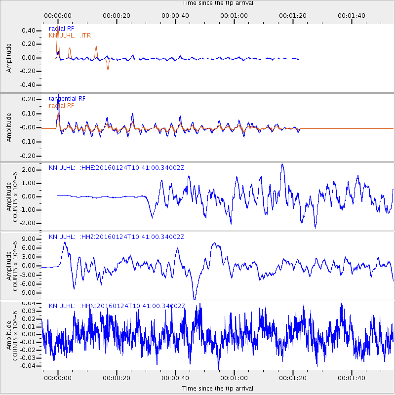
Signal To Noise
| Channel | StoN | STA | LTA |
| KN:ULHL: :HHZ:20160124T10:41:00.34002Z | 53.361958 | 4.290139E-6 | 8.039695E-8 |
| KN:ULHL: :HHN:20160124T10:41:00.34002Z | 1.252576 | 1.4084235E-8 | 1.1244215E-8 |
| KN:ULHL: :HHE:20160124T10:41:00.34002Z | 13.233177 | 7.6782356E-7 | 5.8022618E-8 |
| Arrivals |
| Ps | |
| PpPs | |
| PsPs/PpSs | |


