You are here: Home > Network List > GS - US Geological Survey Networks Stations List
> Station KAN11 Stewart Ranch, Harper County, KS, USA > Earthquake Result Viewer
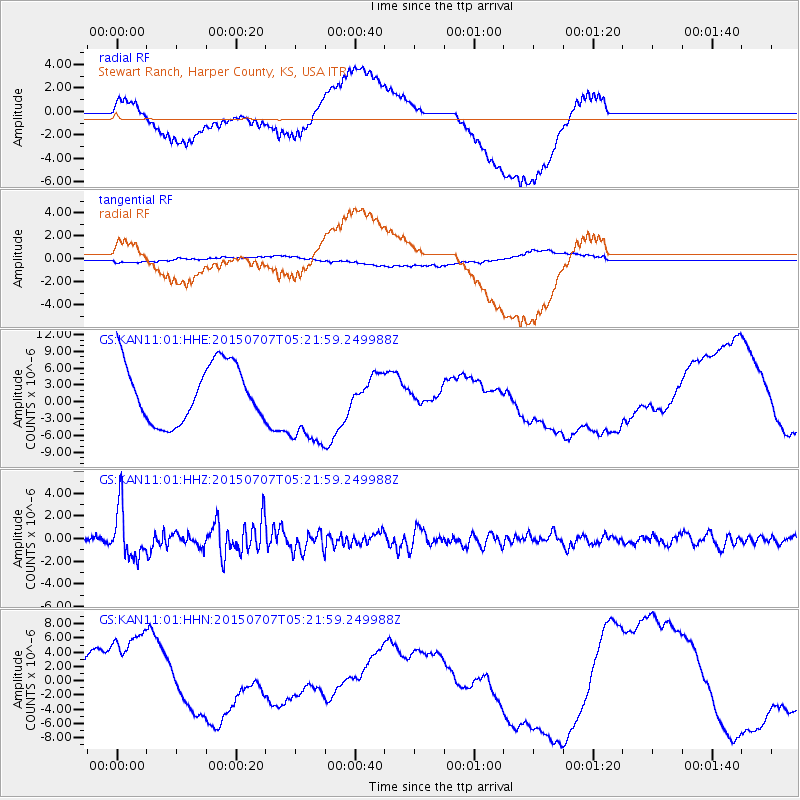
KAN11 Stewart Ranch, Harper County, KS, USA - Earthquake Result Viewer
*The percent match for this event was below the threshold and hence no stack was calculated.
| Earthquake location: |
Kuril Islands |
| Earthquake latitude/longitude: |
44.0/147.9 |
| Earthquake time(UTC): |
2015/07/07 (188) 05:10:27 GMT |
| Earthquake Depth: |
38 km |
| Earthquake Magnitude: |
6.3 MO |
| Earthquake Catalog/Contributor: |
NEIC PDE/NEIC ALERT |
|
| Network: |
GS US Geological Survey Networks |
| Station: |
KAN11 Stewart Ranch, Harper County, KS, USA |
| Lat/Lon: |
37.21 N/97.91 W |
| Elevation: |
410 m |
|
| Distance: |
79.6 deg |
| Az: |
47.796 deg |
| Baz: |
317.956 deg |
| Ray Param: |
$rayparam |
*The percent match for this event was below the threshold and hence was not used in the summary stack. |
|
| Radial Match: |
64.13163 % |
| Radial Bump: |
400 |
| Transverse Match: |
32.802296 % |
| Transverse Bump: |
400 |
| SOD ConfigId: |
976571 |
| Insert Time: |
2015-07-21 05:30:28.409 +0000 |
| GWidth: |
2.5 |
| Max Bumps: |
400 |
| Tol: |
0.001 |
|
Signal To Noise
| Channel | StoN | STA | LTA |
| GS:KAN11:01:HHZ:20150707T05:21:59.249988Z | 9.860727 | 2.194534E-6 | 2.2255297E-7 |
| GS:KAN11:01:HHN:20150707T05:21:59.249988Z | 2.0007298 | 7.0560395E-6 | 3.526733E-6 |
| GS:KAN11:01:HHE:20150707T05:21:59.249988Z | 1.5665568 | 8.024492E-6 | 5.122375E-6 |
| Arrivals |
| Ps | |
| PpPs | |
| PsPs/PpSs | |


