You are here: Home > Network List > LX - University of LISbon SEISmic Network Stations List
> Station MORF Marmelete, Algarve, Portugal > Earthquake Result Viewer
MORF Marmelete, Algarve, Portugal - Earthquake Result Viewer
| Earthquake location: |
Southern Alaska |
| Earthquake latitude/longitude: |
59.7/-153.5 |
| Earthquake time(UTC): |
2016/01/24 (024) 10:30:30 GMT |
| Earthquake Depth: |
128 km |
| Earthquake Magnitude: |
7.1 MWW, 6.4 ML |
| Earthquake Catalog/Contributor: |
NEIC PDE/NEIC COMCAT |
|
| Network: |
LX University of LISbon SEISmic Network |
| Station: |
MORF Marmelete, Algarve, Portugal |
| Lat/Lon: |
37.30 N/8.65 W |
| Elevation: |
560 m |
|
| Distance: |
79.1 deg |
| Az: |
27.911 deg |
| Baz: |
342.661 deg |
| Ray Param: |
0.048892323 |
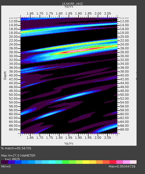
| Estimated Moho Depth: |
27.0 km |
| Estimated Crust Vp/Vs: |
1.89 |
| Assumed Crust Vp: |
6.048 km/s |
| Estimated Crust Vs: |
3.196 km/s |
| Estimated Crust Poisson's Ratio: |
0.31 |
|
| Radial Match: |
85.56705 % |
| Radial Bump: |
400 |
| Transverse Match: |
75.79157 % |
| Transverse Bump: |
400 |
| SOD ConfigId: |
7422571 |
| Insert Time: |
2019-04-21 19:43:05.868 +0000 |
| GWidth: |
2.5 |
| Max Bumps: |
400 |
| Tol: |
0.001 |
|

Signal To Noise
| Channel | StoN | STA | LTA |
| LX:MORF: :HHZ:20160124T10:41:49.114983Z | 5.842331 | 2.2015001E-6 | 3.7681883E-7 |
| LX:MORF: :HHN:20160124T10:41:49.114983Z | 2.8890154 | 9.962233E-7 | 3.4483145E-7 |
| LX:MORF: :HHE:20160124T10:41:49.114983Z | 0.72894967 | 3.5085134E-7 | 4.813108E-7 |
| Arrivals |
| Ps | 4.1 SECOND |
| PpPs | 13 SECOND |
| PsPs/PpSs | 17 SECOND |


