You are here: Home > Network List > N4 - Central and EAstern US Network Stations List
> Station 146B Union, MS, USA > Earthquake Result Viewer
146B Union, MS, USA - Earthquake Result Viewer
| Earthquake location: |
Southern Alaska |
| Earthquake latitude/longitude: |
59.7/-153.5 |
| Earthquake time(UTC): |
2016/01/24 (024) 10:30:30 GMT |
| Earthquake Depth: |
128 km |
| Earthquake Magnitude: |
7.1 MWW, 6.4 ML |
| Earthquake Catalog/Contributor: |
NEIC PDE/NEIC COMCAT |
|
| Network: |
N4 Central and EAstern US Network |
| Station: |
146B Union, MS, USA |
| Lat/Lon: |
32.64 N/89.06 W |
| Elevation: |
161 m |
|
| Distance: |
49.6 deg |
| Az: |
93.134 deg |
| Baz: |
323.073 deg |
| Ray Param: |
0.06814094 |
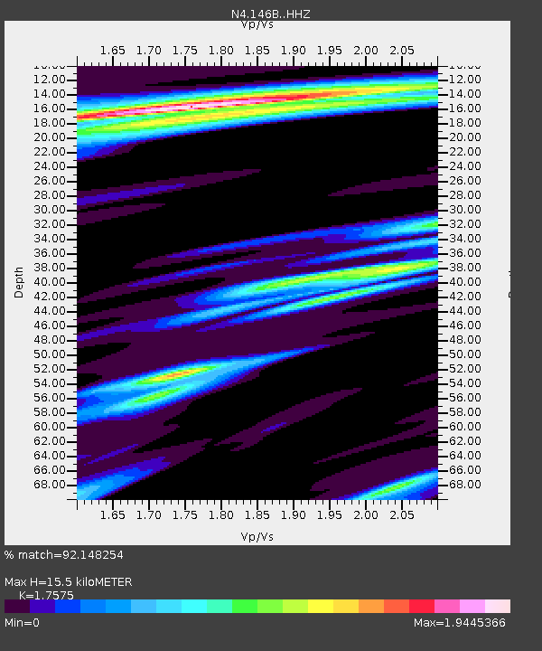
| Estimated Moho Depth: |
15.5 km |
| Estimated Crust Vp/Vs: |
1.76 |
| Assumed Crust Vp: |
6.201 km/s |
| Estimated Crust Vs: |
3.529 km/s |
| Estimated Crust Poisson's Ratio: |
0.26 |
|
| Radial Match: |
92.148254 % |
| Radial Bump: |
400 |
| Transverse Match: |
92.55571 % |
| Transverse Bump: |
400 |
| SOD ConfigId: |
7422571 |
| Insert Time: |
2019-04-21 19:43:18.023 +0000 |
| GWidth: |
2.5 |
| Max Bumps: |
400 |
| Tol: |
0.001 |
|

Signal To Noise
| Channel | StoN | STA | LTA |
| N4:146B: :HHZ:20160124T10:38:37.369988Z | 6.350129 | 4.011666E-6 | 6.3174554E-7 |
| N4:146B: :HHN:20160124T10:38:37.369988Z | 0.87126625 | 1.5596958E-6 | 1.7901482E-6 |
| N4:146B: :HHE:20160124T10:38:37.369988Z | 1.3422997 | 2.7996155E-6 | 2.0856858E-6 |
| Arrivals |
| Ps | 2.0 SECOND |
| PpPs | 6.5 SECOND |
| PsPs/PpSs | 8.5 SECOND |


