You are here: Home > Network List > N4 - Central and EAstern US Network Stations List
> Station 735B Kenedy, TX, USA > Earthquake Result Viewer
735B Kenedy, TX, USA - Earthquake Result Viewer
| Earthquake location: |
Southern Alaska |
| Earthquake latitude/longitude: |
59.7/-153.5 |
| Earthquake time(UTC): |
2016/01/24 (024) 10:30:30 GMT |
| Earthquake Depth: |
128 km |
| Earthquake Magnitude: |
7.1 MWW, 6.4 ML |
| Earthquake Catalog/Contributor: |
NEIC PDE/NEIC COMCAT |
|
| Network: |
N4 Central and EAstern US Network |
| Station: |
735B Kenedy, TX, USA |
| Lat/Lon: |
28.86 N/97.81 W |
| Elevation: |
109 m |
|
| Distance: |
48.3 deg |
| Az: |
104.163 deg |
| Baz: |
325.864 deg |
| Ray Param: |
0.06898421 |
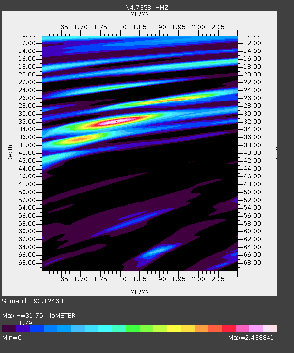
| Estimated Moho Depth: |
31.75 km |
| Estimated Crust Vp/Vs: |
1.79 |
| Assumed Crust Vp: |
5.78 km/s |
| Estimated Crust Vs: |
3.229 km/s |
| Estimated Crust Poisson's Ratio: |
0.27 |
|
| Radial Match: |
93.12468 % |
| Radial Bump: |
400 |
| Transverse Match: |
87.6451 % |
| Transverse Bump: |
400 |
| SOD ConfigId: |
7422571 |
| Insert Time: |
2019-04-21 19:43:22.076 +0000 |
| GWidth: |
2.5 |
| Max Bumps: |
400 |
| Tol: |
0.001 |
|

Signal To Noise
| Channel | StoN | STA | LTA |
| N4:735B: :HHZ:20160124T10:38:27.260002Z | 7.1445947 | 2.1402532E-6 | 2.9956257E-7 |
| N4:735B: :HHN:20160124T10:38:27.260002Z | 1.0074979 | 7.1505326E-7 | 7.097318E-7 |
| N4:735B: :HHE:20160124T10:38:27.260002Z | 2.0267735 | 8.980504E-7 | 4.430936E-7 |
| Arrivals |
| Ps | 4.5 SECOND |
| PpPs | 15 SECOND |
| PsPs/PpSs | 19 SECOND |


