You are here: Home > Network List > N4 - Central and EAstern US Network Stations List
> Station K62A Royalston, MA, USA > Earthquake Result Viewer
K62A Royalston, MA, USA - Earthquake Result Viewer
| Earthquake location: |
Southern Alaska |
| Earthquake latitude/longitude: |
59.7/-153.5 |
| Earthquake time(UTC): |
2016/01/24 (024) 10:30:30 GMT |
| Earthquake Depth: |
128 km |
| Earthquake Magnitude: |
7.1 MWW, 6.4 ML |
| Earthquake Catalog/Contributor: |
NEIC PDE/NEIC COMCAT |
|
| Network: |
N4 Central and EAstern US Network |
| Station: |
K62A Royalston, MA, USA |
| Lat/Lon: |
42.67 N/72.23 W |
| Elevation: |
289 m |
|
| Distance: |
50.3 deg |
| Az: |
71.367 deg |
| Baz: |
319.291 deg |
| Ray Param: |
0.06771711 |
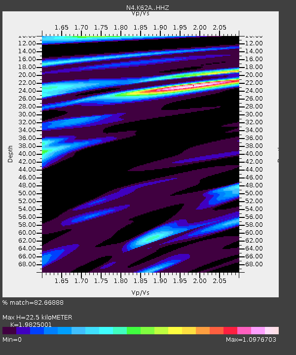
| Estimated Moho Depth: |
22.5 km |
| Estimated Crust Vp/Vs: |
1.98 |
| Assumed Crust Vp: |
6.419 km/s |
| Estimated Crust Vs: |
3.238 km/s |
| Estimated Crust Poisson's Ratio: |
0.33 |
|
| Radial Match: |
82.66888 % |
| Radial Bump: |
308 |
| Transverse Match: |
56.729885 % |
| Transverse Bump: |
368 |
| SOD ConfigId: |
7422571 |
| Insert Time: |
2019-04-21 19:43:36.956 +0000 |
| GWidth: |
2.5 |
| Max Bumps: |
400 |
| Tol: |
0.001 |
|

Signal To Noise
| Channel | StoN | STA | LTA |
| N4:K62A: :HHZ:20160124T10:38:42.360009Z | 2.0731409 | 4.2845986E-6 | 2.0667185E-6 |
| N4:K62A: :HHN:20160124T10:38:42.360009Z | 1.5577391 | 3.071785E-6 | 1.9719507E-6 |
| N4:K62A: :HHE:20160124T10:38:42.360009Z | 1.1047024 | 1.625195E-6 | 1.4711609E-6 |
| Arrivals |
| Ps | 3.6 SECOND |
| PpPs | 9.9 SECOND |
| PsPs/PpSs | 14 SECOND |


