You are here: Home > Network List > NN - Western Great Basin/Eastern Sierra Nevada Stations List
> Station DSP Deep Springs, California w84gm > Earthquake Result Viewer
DSP Deep Springs, California w84gm - Earthquake Result Viewer
| Earthquake location: |
Southern Alaska |
| Earthquake latitude/longitude: |
59.7/-153.5 |
| Earthquake time(UTC): |
2016/01/24 (024) 10:30:30 GMT |
| Earthquake Depth: |
128 km |
| Earthquake Magnitude: |
7.1 MWW, 6.4 ML |
| Earthquake Catalog/Contributor: |
NEIC PDE/NEIC COMCAT |
|
| Network: |
NN Western Great Basin/Eastern Sierra Nevada |
| Station: |
DSP Deep Springs, California w84gm |
| Lat/Lon: |
37.37 N/117.97 W |
| Elevation: |
1692 m |
|
| Distance: |
31.8 deg |
| Az: |
118.601 deg |
| Baz: |
325.981 deg |
| Ray Param: |
0.07857655 |
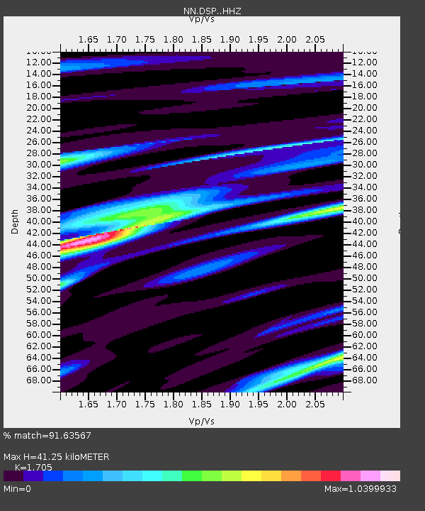
| Estimated Moho Depth: |
41.25 km |
| Estimated Crust Vp/Vs: |
1.71 |
| Assumed Crust Vp: |
6.279 km/s |
| Estimated Crust Vs: |
3.682 km/s |
| Estimated Crust Poisson's Ratio: |
0.24 |
|
| Radial Match: |
91.63567 % |
| Radial Bump: |
346 |
| Transverse Match: |
80.13027 % |
| Transverse Bump: |
400 |
| SOD ConfigId: |
7422571 |
| Insert Time: |
2019-04-21 19:44:34.441 +0000 |
| GWidth: |
2.5 |
| Max Bumps: |
400 |
| Tol: |
0.001 |
|

Signal To Noise
| Channel | StoN | STA | LTA |
| NN:DSP: :HHZ:20160124T10:36:11.167992Z | 22.4953 | 3.3391138E-6 | 1.4843606E-7 |
| NN:DSP: :HHN:20160124T10:36:11.167992Z | 8.250849 | 1.5911529E-6 | 1.9284718E-7 |
| NN:DSP: :HHE:20160124T10:36:11.167992Z | 1.3702186 | 4.6627852E-7 | 3.4029497E-7 |
| Arrivals |
| Ps | 5.0 SECOND |
| PpPs | 16 SECOND |
| PsPs/PpSs | 21 SECOND |


