You are here: Home > Network List > OK - Oklahoma Seismic Network Stations List
> Station CCOK Cow Creek > Earthquake Result Viewer
CCOK Cow Creek - Earthquake Result Viewer
| Earthquake location: |
Southern Alaska |
| Earthquake latitude/longitude: |
59.7/-153.5 |
| Earthquake time(UTC): |
2016/01/24 (024) 10:30:30 GMT |
| Earthquake Depth: |
128 km |
| Earthquake Magnitude: |
7.1 MWW, 6.4 ML |
| Earthquake Catalog/Contributor: |
NEIC PDE/NEIC COMCAT |
|
| Network: |
OK Oklahoma Seismic Network |
| Station: |
CCOK Cow Creek |
| Lat/Lon: |
35.36 N/97.66 W |
| Elevation: |
378 m |
|
| Distance: |
43.1 deg |
| Az: |
98.697 deg |
| Baz: |
322.124 deg |
| Ray Param: |
0.07226582 |
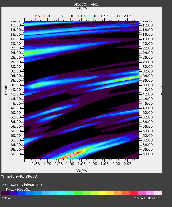
| Estimated Moho Depth: |
68.5 km |
| Estimated Crust Vp/Vs: |
1.80 |
| Assumed Crust Vp: |
6.426 km/s |
| Estimated Crust Vs: |
3.58 km/s |
| Estimated Crust Poisson's Ratio: |
0.27 |
|
| Radial Match: |
91.39623 % |
| Radial Bump: |
354 |
| Transverse Match: |
68.50292 % |
| Transverse Bump: |
400 |
| SOD ConfigId: |
7422571 |
| Insert Time: |
2019-04-21 19:45:02.977 +0000 |
| GWidth: |
2.5 |
| Max Bumps: |
400 |
| Tol: |
0.001 |
|

Signal To Noise
| Channel | StoN | STA | LTA |
| OK:CCOK: :HHZ:20160124T10:37:46.698998Z | 4.1507363 | 1.6822579E-6 | 4.0529144E-7 |
| OK:CCOK: :HHN:20160124T10:37:46.698998Z | 0.44834334 | 7.131842E-7 | 1.5907099E-6 |
| OK:CCOK: :HHE:20160124T10:37:46.698998Z | 1.3472755 | 1.2425595E-6 | 9.222758E-7 |
| Arrivals |
| Ps | 9.0 SECOND |
| PpPs | 28 SECOND |
| PsPs/PpSs | 37 SECOND |


