You are here: Home > Network List > OV - Observatorio Vulcanolżgico y Sismolżgico de Costa Rica Stations List
> Station VPVF VPVF, von Frantzius > Earthquake Result Viewer
VPVF VPVF, von Frantzius - Earthquake Result Viewer
| Earthquake location: |
Southern Alaska |
| Earthquake latitude/longitude: |
59.7/-153.5 |
| Earthquake time(UTC): |
2016/01/24 (024) 10:30:30 GMT |
| Earthquake Depth: |
128 km |
| Earthquake Magnitude: |
7.1 MWW, 6.4 ML |
| Earthquake Catalog/Contributor: |
NEIC PDE/NEIC COMCAT |
|
| Network: |
OV Observatorio Vulcanolżgico y Sismolżgico de Costa Rica |
| Station: |
VPVF VPVF, von Frantzius |
| Lat/Lon: |
10.20 N/84.23 W |
| Elevation: |
2431 m |
|
| Distance: |
70.8 deg |
| Az: |
102.942 deg |
| Baz: |
329.826 deg |
| Ray Param: |
0.054423008 |
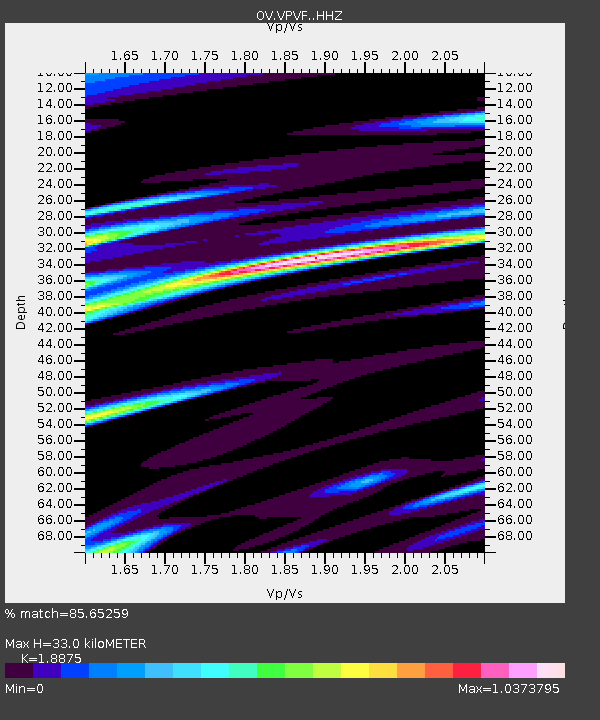
| Estimated Moho Depth: |
33.0 km |
| Estimated Crust Vp/Vs: |
1.89 |
| Assumed Crust Vp: |
6.597 km/s |
| Estimated Crust Vs: |
3.495 km/s |
| Estimated Crust Poisson's Ratio: |
0.30 |
|
| Radial Match: |
85.65259 % |
| Radial Bump: |
400 |
| Transverse Match: |
77.89021 % |
| Transverse Bump: |
400 |
| SOD ConfigId: |
7422571 |
| Insert Time: |
2019-04-21 19:45:17.335 +0000 |
| GWidth: |
2.5 |
| Max Bumps: |
400 |
| Tol: |
0.001 |
|

Signal To Noise
| Channel | StoN | STA | LTA |
| OV:VPVF: :HHZ:20160124T10:41:01.140007Z | 2.0843668 | 5.977943E-7 | 2.86799E-7 |
| OV:VPVF: :HHN:20160124T10:41:01.140007Z | 1.5326762 | 7.639582E-7 | 4.984472E-7 |
| OV:VPVF: :HHE:20160124T10:41:01.140007Z | 1.3167269 | 7.8385375E-7 | 5.9530475E-7 |
| Arrivals |
| Ps | 4.6 SECOND |
| PpPs | 14 SECOND |
| PsPs/PpSs | 19 SECOND |


