You are here: Home > Network List > IC - New China Digital Seismograph Network Stations List
> Station QIZ Qiongzhong, Guangduong Province, China > Earthquake Result Viewer
QIZ Qiongzhong, Guangduong Province, China - Earthquake Result Viewer

| Earthquake location: |
East Of Kuril Islands |
| Earthquake latitude/longitude: |
46.9/155.2 |
| Earthquake time(UTC): |
2009/01/15 (015) 17:49:39 GMT |
| Earthquake Depth: |
36 km |
| Earthquake Magnitude: |
6.9 MB, 7.5 MS, 7.4 MW, 7.4 MW |
| Earthquake Catalog/Contributor: |
WHDF/NEIC |
|
| Network: |
IC New China Digital Seismograph Network |
| Station: |
QIZ Qiongzhong, Guangduong Province, China |
| Lat/Lon: |
19.03 N/109.84 E |
| Elevation: |
230 m |
|
| Distance: |
46.2 deg |
| Az: |
248.754 deg |
| Baz: |
42.541 deg |
| Ray Param: |
0.070727006 |
| Estimated Moho Depth: |
35.75 km |
| Estimated Crust Vp/Vs: |
1.64 |
| Assumed Crust Vp: |
6.182 km/s |
| Estimated Crust Vs: |
3.764 km/s |
| Estimated Crust Poisson's Ratio: |
0.21 |
|
| Radial Match: |
97.90805 % |
| Radial Bump: |
207 |
| Transverse Match: |
94.9077 % |
| Transverse Bump: |
400 |
| SOD ConfigId: |
2834 |
| Insert Time: |
2010-03-04 23:32:18.889 +0000 |
| GWidth: |
2.5 |
| Max Bumps: |
400 |
| Tol: |
0.001 |
|
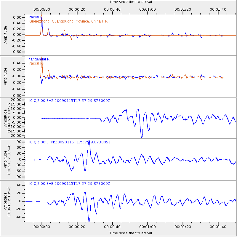
Signal To Noise
| Channel | StoN | STA | LTA |
| IC:QIZ:00:BHN:20090115T17:57:29.873009Z | 16.451464 | 7.719058E-6 | 4.692019E-7 |
| IC:QIZ:00:BHE:20090115T17:57:29.873009Z | 10.138016 | 3.0178403E-6 | 2.9767563E-7 |
| IC:QIZ:00:BHZ:20090115T17:57:29.873009Z | 10.227942 | 1.3465545E-6 | 1.3165449E-7 |
| Arrivals |
| Ps | 4.0 SECOND |
| PpPs | 14 SECOND |
| PsPs/PpSs | 18 SECOND |


