You are here: Home > Network List > PM - Portuguese National Seismic Network Stations List
> Station PESTR ESTREMOZ, PORTUGAL > Earthquake Result Viewer
PESTR ESTREMOZ, PORTUGAL - Earthquake Result Viewer
| Earthquake location: |
Southern Alaska |
| Earthquake latitude/longitude: |
59.7/-153.5 |
| Earthquake time(UTC): |
2016/01/24 (024) 10:30:30 GMT |
| Earthquake Depth: |
128 km |
| Earthquake Magnitude: |
7.1 MWW, 6.4 ML |
| Earthquake Catalog/Contributor: |
NEIC PDE/NEIC COMCAT |
|
| Network: |
PM Portuguese National Seismic Network |
| Station: |
PESTR ESTREMOZ, PORTUGAL |
| Lat/Lon: |
38.87 N/7.59 W |
| Elevation: |
410 m |
|
| Distance: |
77.9 deg |
| Az: |
26.624 deg |
| Baz: |
343.056 deg |
| Ray Param: |
0.049733516 |
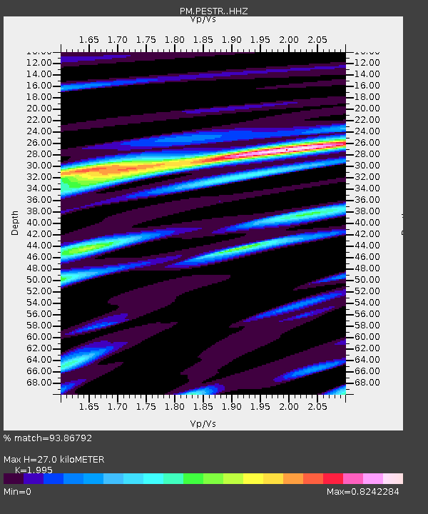
| Estimated Moho Depth: |
27.0 km |
| Estimated Crust Vp/Vs: |
2.00 |
| Assumed Crust Vp: |
6.276 km/s |
| Estimated Crust Vs: |
3.146 km/s |
| Estimated Crust Poisson's Ratio: |
0.33 |
|
| Radial Match: |
93.86792 % |
| Radial Bump: |
272 |
| Transverse Match: |
78.1575 % |
| Transverse Bump: |
400 |
| SOD ConfigId: |
7422571 |
| Insert Time: |
2019-04-21 19:45:38.209 +0000 |
| GWidth: |
2.5 |
| Max Bumps: |
400 |
| Tol: |
0.001 |
|

Signal To Noise
| Channel | StoN | STA | LTA |
| PM:PESTR: :HHZ:20160124T10:41:42.320Z | 5.0147853 | 2.8164338E-6 | 5.61626E-7 |
| PM:PESTR: :HHN:20160124T10:41:42.320Z | 3.563315 | 9.908337E-7 | 2.7806513E-7 |
| PM:PESTR: :HHE:20160124T10:41:42.320Z | 1.5213717 | 5.526976E-7 | 3.6328902E-7 |
| Arrivals |
| Ps | 4.4 SECOND |
| PpPs | 13 SECOND |
| PsPs/PpSs | 17 SECOND |


