You are here: Home > Network List > TA - USArray Transportable Network (new EarthScope stations) Stations List
> Station MDND Maddock, ND, USA > Earthquake Result Viewer
MDND Maddock, ND, USA - Earthquake Result Viewer
| Earthquake location: |
Southern Alaska |
| Earthquake latitude/longitude: |
59.7/-153.5 |
| Earthquake time(UTC): |
2016/01/24 (024) 10:30:30 GMT |
| Earthquake Depth: |
128 km |
| Earthquake Magnitude: |
7.1 MWW, 6.4 ML |
| Earthquake Catalog/Contributor: |
NEIC PDE/NEIC COMCAT |
|
| Network: |
TA USArray Transportable Network (new EarthScope stations) |
| Station: |
MDND Maddock, ND, USA |
| Lat/Lon: |
47.85 N/99.60 W |
| Elevation: |
479 m |
|
| Distance: |
33.0 deg |
| Az: |
86.538 deg |
| Baz: |
311.207 deg |
| Ray Param: |
0.078022726 |
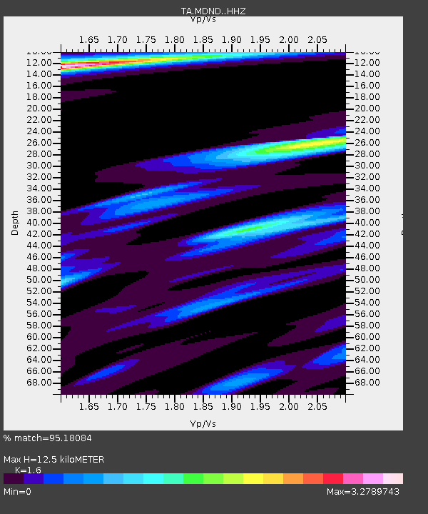
| Estimated Moho Depth: |
12.5 km |
| Estimated Crust Vp/Vs: |
1.60 |
| Assumed Crust Vp: |
6.53 km/s |
| Estimated Crust Vs: |
4.082 km/s |
| Estimated Crust Poisson's Ratio: |
0.18 |
|
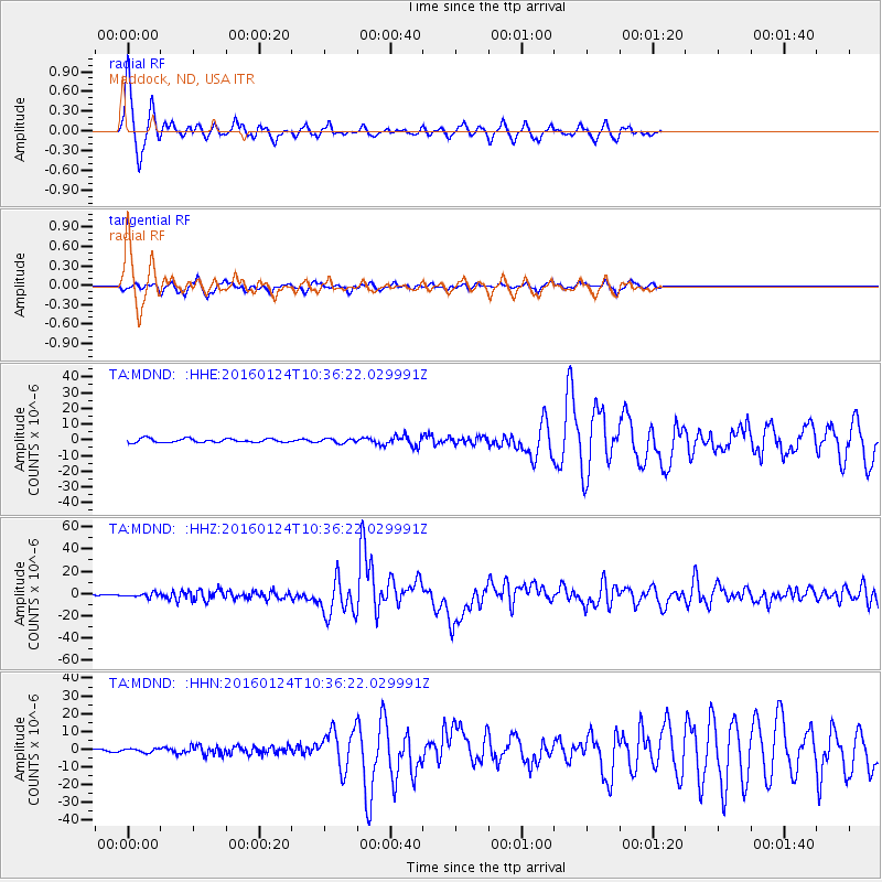
| Radial Match: |
95.18084 % |
| Radial Bump: |
363 |
| Transverse Match: |
85.747696 % |
| Transverse Bump: |
385 |
| SOD ConfigId: |
7422571 |
| Insert Time: |
2019-04-21 19:46:20.469 +0000 |
| GWidth: |
2.5 |
| Max Bumps: |
400 |
| Tol: |
0.001 |
|
Signal To Noise
| Channel | StoN | STA | LTA |
| TA:MDND: :HHZ:20160124T10:36:22.029991Z | 3.0872016 | 1.8115488E-6 | 5.867932E-7 |
| TA:MDND: :HHN:20160124T10:36:22.029991Z | 0.6964211 | 1.0799328E-6 | 1.5506894E-6 |
| TA:MDND: :HHE:20160124T10:36:22.029991Z | 1.2140553 | 1.4016161E-6 | 1.1544912E-6 |
| Arrivals |
| Ps | 1.3 SECOND |
| PpPs | 4.6 SECOND |
| PsPs/PpSs | 5.8 SECOND |


